IMAGES TAKEN NEAR TO
Willis Street, MILTON KEYNES, MK3 5RE
Introduction
This page details the photographs taken nearby to Willis Street, MK3 5RE by members of the Geograph project.
The Geograph project started in 2005 with the aim of publishing, organising and preserving representative images for every square kilometre of Great Britain, Ireland and the Isle of Man.

There are currently over 7.5m images from over14,400 individuals and you can help contribute to the project by visiting https://www.geograph.org.uk
Image Map
Images are licensed for reuse under creativecommons.org/licenses/by-sa/2.0
Notes
- Clicking on the map will re-center to the selected point.
- The higher the marker number, the further away the image location is from the centre of the postcode.
Image Listing (19 Images Found)
Images are licensed for reuse under creativecommons.org/licenses/by-sa/2.0
Image
Details
Distance
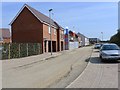
1
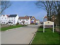
Newton Leys (1), Bletchley
A new estate built on the site of old brickworks.
Image: © Cameraman
Taken: 10 Apr 2010
0.06 miles
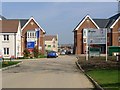

7
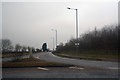
Aylesbury Vale : Stoke Road
A road off of the roundabout.
Image: © Lewis Clarke
Taken: 24 Mar 2018
0.09 miles
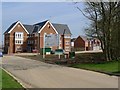
8
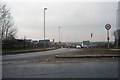
Aylesbury Vale : Drayton Road
Drayton Road heading into Bletchley.
Image: © Lewis Clarke
Taken: 24 Mar 2018
0.09 miles
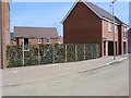
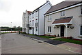
10
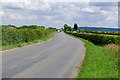
Road Leading to Bletchley, Milton Keynes
Image: © Cameraman
Taken: 29 Jun 2011
0.11 miles