IMAGES TAKEN NEAR TO
Langdale Close, MILTON KEYNES, MK2 3QA
Introduction
This page details the photographs taken nearby to Langdale Close, MK2 3QA by members of the Geograph project.
The Geograph project started in 2005 with the aim of publishing, organising and preserving representative images for every square kilometre of Great Britain, Ireland and the Isle of Man.

There are currently over 7.5m images from over14,400 individuals and you can help contribute to the project by visiting https://www.geograph.org.uk
Image Map
Images are licensed for reuse under creativecommons.org/licenses/by-sa/2.0
Notes
- Clicking on the map will re-center to the selected point.
- The higher the marker number, the further away the image location is from the centre of the postcode.
Image Listing (7 Images Found)
Images are licensed for reuse under creativecommons.org/licenses/by-sa/2.0
Image
Details
Distance
1
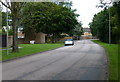
Lomond Drive in Water Eaton
This road forms the southern most part of Milton Keynes.
Image: © Mat Fascione
Taken: 16 Aug 2015
0.05 miles
2
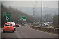
Aylesbury Vale : Stoke Hammond and Linslade Western Bypass A4146
A road heads around the town of Milton Keynes.
Image: © Lewis Clarke
Taken: 24 Mar 2018
0.09 miles
4
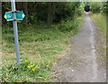
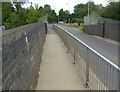
Public footpath at Water Eaton
This path leads south alongside the West Coast Main Line, under the A4146, to the village of Stoke Hammond.
Image: © Mat Fascione
Taken: 16 Aug 2015
0.18 miles
5
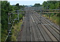
West Coast Main Line towards central Milton Keynes
Looking north from the Drayton Road bridge.
Image: © Mat Fascione
Taken: 16 Aug 2015
0.18 miles
6
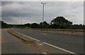
Drayton Road crossing the West Coast Main Line
Image: © Mat Fascione
Taken: 16 Aug 2015
0.18 miles
7
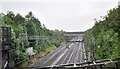
West Coast Main Line
Looking from Drayton Road bridge (No. 149) south towards the A4146 road bridge (No. 148A) on a damp June afternoon - no trains as there was a strike in progress.
Image: © Bob Walters
Taken: 23 Jun 2022
0.24 miles