IMAGES TAKEN NEAR TO
Frensham Drive, MILTON KEYNES, MK2 3AR
Introduction
This page details the photographs taken nearby to Frensham Drive, MK2 3AR by members of the Geograph project.
The Geograph project started in 2005 with the aim of publishing, organising and preserving representative images for every square kilometre of Great Britain, Ireland and the Isle of Man.

There are currently over 7.5m images from over14,400 individuals and you can help contribute to the project by visiting https://www.geograph.org.uk
Image Map
Images are licensed for reuse under creativecommons.org/licenses/by-sa/2.0
Notes
- Clicking on the map will re-center to the selected point.
- The higher the marker number, the further away the image location is from the centre of the postcode.
Image Listing (6 Images Found)
Images are licensed for reuse under creativecommons.org/licenses/by-sa/2.0
Image
Details
Distance
1
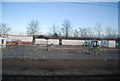
Storage area by the West Coast Main Line
Image: © N Chadwick
Taken: 18 Dec 2011
0.05 miles
2
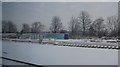
Railway infrastructure near Water Eaton
Various tracks, portacabins, sleeper and transformers stored by the West Coast Main Line.
Image: © N Chadwick
Taken: 19 Dec 2010
0.10 miles
4
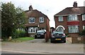
Houses on Water Eaton Road, Fenny Stratford
Image: © David Howard
Taken: 22 Aug 2021
0.14 miles
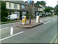
5
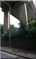
Railway bridge over Water Eaton Road, Bletchley
Image: © David Howard
Taken: 22 Aug 2021
0.23 miles
6
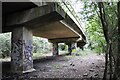
Underneath Bletchley Flyover
Looking underneath Bletchley Flyover before refurbishment works began. This view is from the old trackbed of the line into Bletchley Station before the flyover was built in 1959.
Image: © Bob Walters
Taken: 18 Aug 2018
0.23 miles