IMAGES TAKEN NEAR TO
Watling Terrace, MILTON KEYNES, MK2 2BT
Introduction
This page details the photographs taken nearby to Watling Terrace, MK2 2BT by members of the Geograph project.
The Geograph project started in 2005 with the aim of publishing, organising and preserving representative images for every square kilometre of Great Britain, Ireland and the Isle of Man.

There are currently over 7.5m images from over14,400 individuals and you can help contribute to the project by visiting https://www.geograph.org.uk
Image Map
Images are licensed for reuse under creativecommons.org/licenses/by-sa/2.0
Notes
- Clicking on the map will re-center to the selected point.
- The higher the marker number, the further away the image location is from the centre of the postcode.
Image Listing (80 Images Found)
Images are licensed for reuse under creativecommons.org/licenses/by-sa/2.0
Image
Details
Distance
1
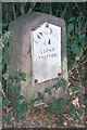
Old Milestone by the former A5, south east of Fenny Stratford
Metal plate attached to stone post by the UC road (was A5), in parish of Bletchley (Milton Keynes District), Watling Street; between river bridge and canal bridge, opposite Attic Restaurant, in hedge, behind footpath, on South side of road. Milton Keynes iron plate, erected by the Holyhead Road (Hockliffe Division) turnpike trust in the 19th century.
Inscription reads:-
LONDON
44
STONY
STRATFORD
7
Carved benchmark on lower front face.
Milestone Society National ID: BU_LH44
Image: © A Rosevear & J Higgins
Taken: 11 Jul 2003
0.04 miles
2
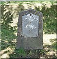
Old Milestone by the former A5, Watling Street, Fenny Stratford
Metal plate attached to stone post by the UC road (was A5), in parish of Bletchley (Milton Keynes District), Watling Street; between river bridge and canal bridge, opposite Attic Restaurant, in hedge, behind footpath, on South side of road. Milton Keynes iron plate, erected by the Holyhead Road (Hockliffe Div) Turnpike Trust in the 19th century.
Inscription reads:-
LONDON
44
STONY
STRATFORD
7
Carved benchmark on lower front face.
Milestone Society National ID: BU_LH44.
Image: © Milestone Society
Taken: 22 Jun 2018
0.04 miles
3
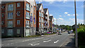
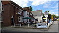
New Flats beside the Watling Street, Fenny Stratford
Located on the outskirts of Fenny Stratford.
Image: © Cameraman
Taken: 23 Aug 2009
0.04 miles
4
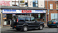
The Kitchen Outlet Store, High Street South
Image: © Cameraman
Taken: 23 Aug 2009
0.05 miles
5
Threads and Patches, High Street South, Fenny Stratford
Formerly The Bull, this pub is on the site of a much older pub also called The Bull. Unfortunately, recent years have seen several name changes including The Monastery and the Roman Way. In the past year or so it has changed from a public house to a handicrafts shop.
Image: © Cameraman
Taken: 23 Aug 2009
0.06 miles
6
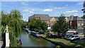
The Grenville Marina in Fenny Stratford
A private marina along the Grand Union Canal.
Image: © Mat Fascione
Taken: 8 Aug 2015
0.07 miles
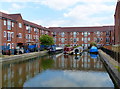
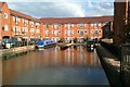
7
Grand Union Canal at Fenny Stratford
Canal-side Living, the narrow boats contrast nicely with the very new apartments.
Image: © Cameraman
Taken: 23 Aug 2009
0.07 miles
9
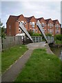
Lifting bridge on the Grand Union Canal
Bridge 96A lifts to gives access across the towpath to a private marina
Image: © Mike W Hallett
Taken: 13 Jun 2009
0.07 miles
10
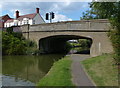
Watling Street Bridge No 96
Crossing the Grand Union Canal in Fenny Stratford.
Image: © Mat Fascione
Taken: 8 Aug 2015
0.07 miles