IMAGES TAKEN NEAR TO
High Street, MILTON KEYNES, MK19 7DT
Introduction
This page details the photographs taken nearby to High Street, MK19 7DT by members of the Geograph project.
The Geograph project started in 2005 with the aim of publishing, organising and preserving representative images for every square kilometre of Great Britain, Ireland and the Isle of Man.

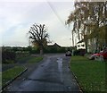
There are currently over 7.5m images from over14,400 individuals and you can help contribute to the project by visiting https://www.geograph.org.uk
Image Map
Images are licensed for reuse under creativecommons.org/licenses/by-sa/2.0
Notes
- Clicking on the map will re-center to the selected point.
- The higher the marker number, the further away the image location is from the centre of the postcode.
Image Listing (24 Images Found)
Images are licensed for reuse under creativecommons.org/licenses/by-sa/2.0
Image
Details
Distance
1
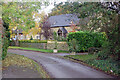
Rectory Road, Haversham
Rectory Road, with its stone cottages, connects High Street with St Mary's Church.
Image: © Stephen McKay
Taken: 23 Oct 2020
0.02 miles
2
The Old Forge, Haversham
The Old Forge at the south western end of the village. The Greyhound PH is visible beyond it.
Image: © mick finn
Taken: 8 Nov 2008
0.03 miles
4
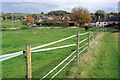
Horse paddock, Haversham
This field, just to the north of Haversham church, is divided by a network of electric fences into a number of horse paddocks. The track on the right is a public footpath.
Image: © Stephen McKay
Taken: 23 Oct 2020
0.03 miles
5
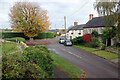
Haversham Village
This is the centre of the old village dominated by the horse chestnut tree at the junction; the Greyhound pub is to the right of that.
Image: © Stephen McKay
Taken: 23 Oct 2020
0.04 miles
6
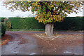
Horse chestnut at Haversham
Many road junctions just have a bollard but here in Haversham there is a splendid horse chestnut tree for traffic to drive around, located outside the Greyhound pub. According to Robert Coles on the mk50trees website it 'symbolises the centre of the community far more strongly than any building; it defines the place. It also provides shade and conkers for anyone enjoying our tiny village pub – and the conkers always remind me of my youth at school!' See http://www.mk50trees.com/gallery.html .
Image: © Stephen McKay
Taken: 23 Oct 2020
0.04 miles
7
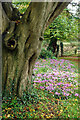
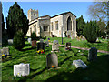
Haversham Churchyard
A gnarled old tree stands guard over the tidy churchyard belonging to St Mary's church.
Image: © Stephen McKay
Taken: 23 Oct 2020
0.05 miles
8
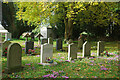
Haversham Churchyard
Some quite recent gravestones in this part of the tidy churchyard belonging to St Mary's church.
Image: © Stephen McKay
Taken: 23 Oct 2020
0.05 miles
9
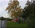
High Street, Haversham
The High Street continues to the right past the old conker tree. The stone building nearest is the Old Forge and the adjoining building is The Greyhound.
Image: © mick finn
Taken: 8 Nov 2008
0.05 miles
10
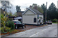
The Greyhound, Haversham
This pub, dating from the 16th century, stands in the old part of the village a short distance from the church. Note also the old Bucks County signpost - this area is now part of Milton Keynes.
Image: © Stephen McKay
Taken: 23 Oct 2020
0.05 miles