IMAGES TAKEN NEAR TO
Stratford Road, MILTON KEYNES, MK19 6DF
Introduction
This page details the photographs taken nearby to Stratford Road, MK19 6DF by members of the Geograph project.
The Geograph project started in 2005 with the aim of publishing, organising and preserving representative images for every square kilometre of Great Britain, Ireland and the Isle of Man.

There are currently over 7.5m images from over14,400 individuals and you can help contribute to the project by visiting https://www.geograph.org.uk
Image Map
Images are licensed for reuse under creativecommons.org/licenses/by-sa/2.0
Notes
- Clicking on the map will re-center to the selected point.
- The higher the marker number, the further away the image location is from the centre of the postcode.
Image Listing (15 Images Found)
Images are licensed for reuse under creativecommons.org/licenses/by-sa/2.0
Image
Details
Distance
1
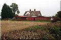
Houses on the corner of Wicken Park Road
Image: © Philip Jeffrey
Taken: 22 Oct 2012
0.01 miles

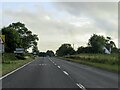
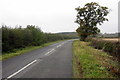
8

South Northamptonshire : The A422
Heading through South Northamptonshire on the A422.
Image: © Lewis Clarke
Taken: 18 Mar 2019
0.14 miles
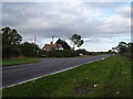
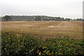
9
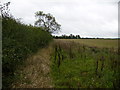
Field margin north of Little Hill Farm
Image: © Phil Catterall
Taken: 6 Oct 2006
0.15 miles
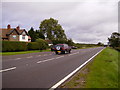
10
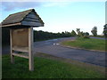
Disused Car Park
This site looks to have seen little maintenance recently, indicated by the unreadable signage. On modern maps it's not indicated as a stop site, however my 1997 OS Explorer states this as parking area, along with a sign along the A422.
Image: © Mr Biz
Taken: 16 Oct 2010
0.16 miles