IMAGES TAKEN NEAR TO
Leckhampstead, BUCKINGHAM, MK18 5NS
Introduction
This page details the photographs taken nearby to MK18 5NS by members of the Geograph project.
The Geograph project started in 2005 with the aim of publishing, organising and preserving representative images for every square kilometre of Great Britain, Ireland and the Isle of Man.

There are currently over 7.5m images from over14,400 individuals and you can help contribute to the project by visiting https://www.geograph.org.uk
Image Map
Images are licensed for reuse under creativecommons.org/licenses/by-sa/2.0
Notes
- Clicking on the map will re-center to the selected point.
- The higher the marker number, the further away the image location is from the centre of the postcode.
Image Listing (14 Images Found)
Images are licensed for reuse under creativecommons.org/licenses/by-sa/2.0
Image
Details
Distance
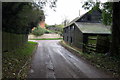
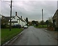
3
Passing Middle End
Lane passing Middle End Leckhampstead
Image: © Shaun Ferguson
Taken: 16 Jun 2010
0.11 miles
4
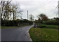
South End Bridge, Leckhampstead
Looking towards Middle End.
Image: © mick finn
Taken: 16 Nov 2008
0.18 miles
5
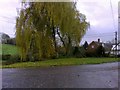
River Bank, Leckhampstead
Willow trees line the north bank of the stream at South End, Leckhampstead.
Image: © mick finn
Taken: 16 Nov 2008
0.18 miles
6
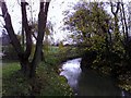
View of the stream, Leckhampstead
Easterly view of the stream from South End Bridge.
Image: © mick finn
Taken: 16 Nov 2008
0.18 miles
7
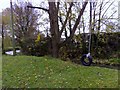
Swings, Leckhampstead
A homemade adventure playground on the riverbank at South End, Leckhampstead. Apart from the tyre swing, a board swing can be seen on the left bough of the tree.
Image: © mick finn
Taken: 16 Nov 2008
0.18 miles
8
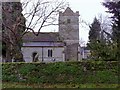
St Mary the Virgin, Leckhampstead
The parish church at Leckhampstead. The first recorded rector was Thomas de Nevill in 1219 (ack. GenUKI).
Image: © mick finn
Taken: 16 Nov 2008
0.19 miles
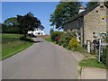
9
Church End, Leckhampstead
The main street in this part of the village. Part of what looks like the village hall can be seen on the right.
Image: © mick finn
Taken: 16 Nov 2008
0.19 miles
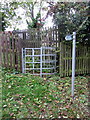
10
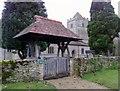
Lychgate, Leckhampstead
The lychgate at St Mary the Virgin, Leckhampstead. The blue plaque indicates that the village was recorded in the Domesday Book of 1086 ('Lechamstede' - ack. Wiki).
Image: © mick finn
Taken: 16 Nov 2008
0.19 miles