IMAGES TAKEN NEAR TO
Leckhampstead Road, BUCKINGHAM, MK18 5HD
Introduction
This page details the photographs taken nearby to Leckhampstead Road, MK18 5HD by members of the Geograph project.
The Geograph project started in 2005 with the aim of publishing, organising and preserving representative images for every square kilometre of Great Britain, Ireland and the Isle of Man.

There are currently over 7.5m images from over14,400 individuals and you can help contribute to the project by visiting https://www.geograph.org.uk
Image Map
Images are licensed for reuse under creativecommons.org/licenses/by-sa/2.0
Notes
- Clicking on the map will re-center to the selected point.
- The higher the marker number, the further away the image location is from the centre of the postcode.
Image Listing (24 Images Found)
Images are licensed for reuse under creativecommons.org/licenses/by-sa/2.0
Image
Details
Distance
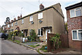
2
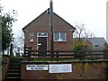
Telephone Exchange, Akeley
Situated in Chapel Lane, Akeley, MK18 5HU, this TE, which has the code SMLD, replaced the former TE in Lillingstone Dayrell in the early 1970s, SP6939 refers http://www.geograph.org.uk/photo/1401343. It provides telephone and broadband services to 370 residential and 26 non-residential premises in two places, plus Leckhampstead and Lillingstone Lovell nearby. The numbering range of this TE is (01280) 860xxx, the (01280) referring to the Buckingham group of TEs.
Image: © David Hillas
Taken: 7 Mar 2009
0.12 miles

5
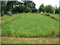
Ghost of a church
Picked out in mown grass, the outline can be seen of where the erstwhile church of St.James the Apostle once stood in its churchyard in Akeley. A church had existed in Akeley since at least 1164, but this was replaced by a new building in 1854 - there is a plan of this later church here - http://www.churchplansonline.org/show_full_image.asp?resource_id=04774.tif
This new church was obviously not as well constructed as the old one however as it required demolishing in 1979 due to the parlous state of its stonework. The church had rectors dating back to 1234 see http://met.open.ac.uk/genuki/big/eng/BKM/Akeley/rectors.html
Here is a link to a photograph of the 1854 church taken c. 1960
http://www.buckscc.gov.uk/photo_database/photodb_detail.asp?Counter=72
Image: © Rob Farrow
Taken: 17 Jun 2006
0.14 miles
6
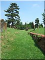
Old pathway to church
The churchyard in Akeley is a little mysterious. The church of St.James the Apostle is no longer there and the gravestones lean in towards the sunken path.
See http://www.churchplansonline.org/show_full_image.asp?resource_id=04774.tif and http://met.open.ac.uk/genuki/big/eng/BKM/Akeley/rectors.html
Image: © Rob Farrow
Taken: 17 Jun 2006
0.14 miles
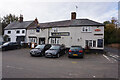
7
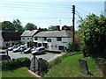
Bull & Butcher, Akeley
Taken over the gate to the churchyard of a church that no longer exists.
Image: © Rob Farrow
Taken: 17 Jun 2006
0.14 miles
8
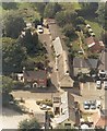
The Square, Akeley in 1996
Aerial view taken in 1996 when we had just completed the renovation of Verendale, the thatched cottage at the centre of the picture.
The brick cottage is The Old School House and the building in the foreground is The Old School. The Bull & Butcher PH in The Square is part seen far right.
Image: © Geoff Spink
Taken: Unknown
0.14 miles