IMAGES TAKEN NEAR TO
Dadford, BUCKINGHAM, MK18 5DH
Introduction
This page details the photographs taken nearby to MK18 5DH by members of the Geograph project.
The Geograph project started in 2005 with the aim of publishing, organising and preserving representative images for every square kilometre of Great Britain, Ireland and the Isle of Man.

There are currently over 7.5m images from over14,400 individuals and you can help contribute to the project by visiting https://www.geograph.org.uk
Image Map
Images are licensed for reuse under creativecommons.org/licenses/by-sa/2.0
Notes
- Clicking on the map will re-center to the selected point.
- The higher the marker number, the further away the image location is from the centre of the postcode.
Image Listing (19 Images Found)
Images are licensed for reuse under creativecommons.org/licenses/by-sa/2.0
Image
Details
Distance
1
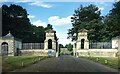
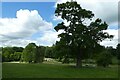
Gateway into Stowe Park
This entrance goes to Stowe House which is now a school, and to the adjoining school buildings and areas of the park which are not part of Stowe Landscape Gardens.
Most public access is via Stowe Avenue a bit to the east of here.
Image: © Des Blenkinsopp
Taken: 23 Aug 2024
0.06 miles
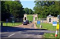
2
The entrance to Stowe School
This is part of a short section of Roman road.
Image: © David Howard
Taken: 17 Sep 2023
0.07 miles
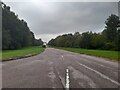
5
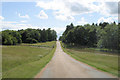
Stowe - Bridge over Oxford Water
The die-straight approach to Stowe parallels a Roman Road situated to the east.
Image: © Stuart Logan
Taken: 23 Jun 2011
0.12 miles
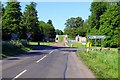
6
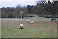
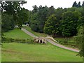
Sheep above Oxford Bridge
The Oxford Avenue entrance to the Stowe House estate is below. It is viewed here from Queen's Drive.
Image: © Bill Boaden
Taken: 24 Nov 2018
0.12 miles
7
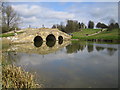
Stowe: The Oxford Bridge and Water
Oxford Water is an artificial serpentine lake created by the damming of the original small stream from the village of Dadford. The Bridge was built in 1761 to carry the main approach track to Stowe from the Oxford direction. The Boycott Pavilion in Image is visible to the left of the track on the brow of the hill.
Image: © Nigel Cox
Taken: 16 Apr 2006
0.13 miles
8
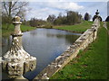
Stowe: Oxford Water
The lake viewed looking from the Oxford Bridge.
Image: © Nigel Cox
Taken: 16 Apr 2006
0.13 miles
9
Towards Oxford Bridge
Looking across to the road to Stowe School from a path to the Corinthian Arch.
Image: © DS Pugh
Taken: 28 May 2022
0.13 miles
10
The Oxford Bridge, Stowe
Built in 1761. See http://www.britishlistedbuildings.co.uk/en-396661-the-oxford-bridge-stowe-buckinghamshire#.Vd7XeflViko for entry in British Listed Buildings.
Image: © Bikeboy
Taken: 20 Aug 2015
0.14 miles