IMAGES TAKEN NEAR TO
Upper Street, BUCKINGHAM, MK18 4QJ
Introduction
This page details the photographs taken nearby to Upper Street, MK18 4QJ by members of the Geograph project.
The Geograph project started in 2005 with the aim of publishing, organising and preserving representative images for every square kilometre of Great Britain, Ireland and the Isle of Man.

There are currently over 7.5m images from over14,400 individuals and you can help contribute to the project by visiting https://www.geograph.org.uk
Image Map
Images are licensed for reuse under creativecommons.org/licenses/by-sa/2.0
Notes
- Clicking on the map will re-center to the selected point.
- The higher the marker number, the further away the image location is from the centre of the postcode.
Image Listing (31 Images Found)
Images are licensed for reuse under creativecommons.org/licenses/by-sa/2.0
Image
Details
Distance
1
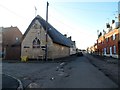
Main Street and Sunday School, Tingewick
Dated 1828. See http://www.britishlistedbuildings.co.uk/en-396879-sunday-school-and-cottage-to-west-tingew for entry in British Listed Buildings. The street was the A421 until the village was bypassed in 1998.
Image: © Bikeboy
Taken: 2 Jan 2015
0.09 miles
2
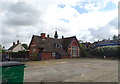
Roundwood Primary School (Tingewick)
On Main Street.
Image: © JThomas
Taken: 28 Sep 2019
0.09 miles
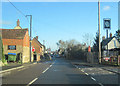
7
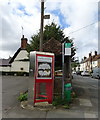
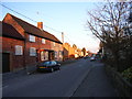
Former telephone kiosk and bus stop on Main Street, Tingewick
Telephone kiosk now houses a defibrillator.
Note the older bus stop sign on the post.
Image: © JThomas
Taken: 28 Sep 2019
0.10 miles
8
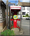
Defibrillator on Main Street, Tingewick
See Image] for context.
Image: © JThomas
Taken: 28 Sep 2019
0.11 miles
10
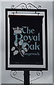
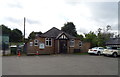
Sign for the Royal Oak, Tingewick
See Image] for context.
Image: © JThomas
Taken: 28 Sep 2019
0.11 miles