IMAGES TAKEN NEAR TO
Field Close, BUCKINGHAM, MK18 4PR
Introduction
This page details the photographs taken nearby to Field Close, MK18 4PR by members of the Geograph project.
The Geograph project started in 2005 with the aim of publishing, organising and preserving representative images for every square kilometre of Great Britain, Ireland and the Isle of Man.

There are currently over 7.5m images from over14,400 individuals and you can help contribute to the project by visiting https://www.geograph.org.uk
Image Map
Images are licensed for reuse under creativecommons.org/licenses/by-sa/2.0
Notes
- Clicking on the map will re-center to the selected point.
- The higher the marker number, the further away the image location is from the centre of the postcode.
Image Listing (36 Images Found)
Images are licensed for reuse under creativecommons.org/licenses/by-sa/2.0
Image
Details
Distance


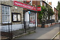
3
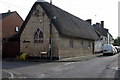
Tingewick Tollhouse, Main Street, Tingewick
Tollhouse in the parish of Tingewick (Aylesbury Vale District), Church View, Main Street, MK18.
Grade II listed.
List Entry Number: 1212376 https://historicengland.org.uk/listing/the-list/list-entry/1212376
Surveyed
Milestone Society National ID: BU.TIN
Image: © Alan Rosevear
Taken: Unknown
0.10 miles
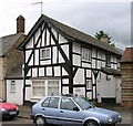
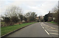
4
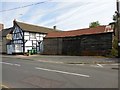
Tingewick Main Street
Cottage and old barn.
Image: © Ian Rob
Taken: 16 Aug 2016
0.11 miles
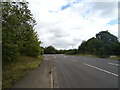
8
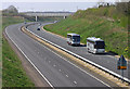
Tingewick Bypass
Looking west, with little traffic.
Image: © Martin Loader
Taken: 8 Apr 2007
0.15 miles