IMAGES TAKEN NEAR TO
Leyland Close, BUCKINGHAM, MK18 4FG
Introduction
This page details the photographs taken nearby to Leyland Close, MK18 4FG by members of the Geograph project.
The Geograph project started in 2005 with the aim of publishing, organising and preserving representative images for every square kilometre of Great Britain, Ireland and the Isle of Man.

There are currently over 7.5m images from over14,400 individuals and you can help contribute to the project by visiting https://www.geograph.org.uk
Image Map
Images are licensed for reuse under creativecommons.org/licenses/by-sa/2.0
Notes
- Clicking on the map will re-center to the selected point.
- The higher the marker number, the further away the image location is from the centre of the postcode.
Image Listing (42 Images Found)
Images are licensed for reuse under creativecommons.org/licenses/by-sa/2.0
Image
Details
Distance
2
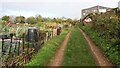
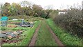
Path heading up to Hodding Wood
From Main Street the path heading up past the allotments to Hodding Wood
Image: © Shaun Ferguson
Taken: 26 Oct 2020
0.08 miles
3
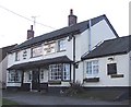
The Cuckoo's Nest, Gawcott
This pub is on the junction of Back Street with Inn Lane a few yards off the Main Street through Gawcott.
Image: © Rob Farrow
Taken: 23 Feb 2007
0.09 miles
4
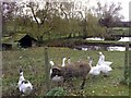
Ponds at Gawcott (with Residents)
The residents could make a very tempting alliterative menu item.
Image: © mick finn
Taken: 15 Nov 2008
0.10 miles
5
Path into Hodding Wood
From Main Street the path heads past the allotments into Hodding Wood
Image: © Shaun Ferguson
Taken: 26 Oct 2020
0.12 miles
6
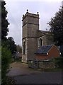
Church tower, Gawcott
The tower of Holy Trinity, Gawcott.
Image: © mick finn
Taken: 15 Nov 2008
0.13 miles
7
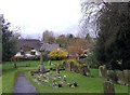
Churchyard, Gawcott
The western side of the churchyard at Holy Trinity. Beyond the wall at the bottom is Main Street.
Image: © mick finn
Taken: 15 Nov 2008
0.13 miles
8
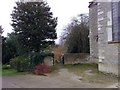
Gateway to Churchyard, Gawcott
Attractive gated entrance to the churchyard at Holy Trinity.
Image: © mick finn
Taken: 15 Nov 2008
0.13 miles
9
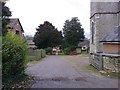
Gated Road, Gawcott
A gated road through the church grounds between Church Street and Main Street.
Image: © mick finn
Taken: 15 Nov 2008
0.13 miles
10
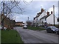
Main Street, Gawcott - view to West
A view down the main village street (helpfully called Main Street) in Gawcott.
The churchyard of Image] is behind a wall immediately to the left (south) of the photographer's position. (Cf. Image])
Image: © Rob Farrow
Taken: 23 Feb 2007
0.13 miles