IMAGES TAKEN NEAR TO
Banbury Road, BUCKINGHAM, MK18 4BH
Introduction
This page details the photographs taken nearby to Banbury Road, MK18 4BH by members of the Geograph project.
The Geograph project started in 2005 with the aim of publishing, organising and preserving representative images for every square kilometre of Great Britain, Ireland and the Isle of Man.

There are currently over 7.5m images from over14,400 individuals and you can help contribute to the project by visiting https://www.geograph.org.uk
Image Map
Images are licensed for reuse under creativecommons.org/licenses/by-sa/2.0
Notes
- Clicking on the map will re-center to the selected point.
- The higher the marker number, the further away the image location is from the centre of the postcode.
Image Listing (19 Images Found)
Images are licensed for reuse under creativecommons.org/licenses/by-sa/2.0
Image
Details
Distance
3
County Boundary marker Bucks and Oxfordshire at Finmere
Image: © michael
Taken: 12 Aug 2011
0.02 miles
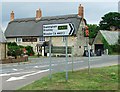
4
Little Tingewick-The Red Lion
On Mere Road.
Image: © Ian Rob
Taken: 16 Aug 2016
0.02 miles
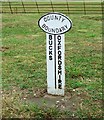
5
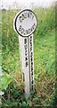
Old Boundary Marker by Sandpit Hill, Finmere
County Boundary Marker by the UC road, in parish of Finmere (Cherwell District), opposite Red Lion PH, Finmere at junction of old roads, on grass verge at the junction.
Inscription reads:-
: BUCKS : : COUNTY / BOUNDARY : : OXFORDSHIRE :
Surveyed
Milestone Society National ID: OX_LC60cb
Image: © Milestone Society
Taken: Unknown
0.02 miles
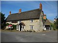
6
The Red Lion, Little Tingewick (2)
Built in C17/C18. See http://www.britishlistedbuildings.co.uk/en-396795-the-red-lion-tingewick-buckinghamshire for entry in British Listed Buildings
Image: © Bikeboy
Taken: 2 Jan 2015
0.02 miles
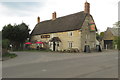
7
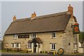
The Red Lion, Little Tingewick
Thatched pub and restaurant. The Roman road from Bicester to Towcester here ceases to be the main A4421 and becomes the village street. The alignment still forms the county boundary between Oxfordshire and Buckinghamshire.
Image: © Fractal Angel
Taken: 29 Apr 2007
0.04 miles
8
The Red Lion, Little Tingewick
Built in C17/C18. See http://www.britishlistedbuildings.co.uk/en-396795-the-red-lion-tingewick-buckinghamshire for entry in British Listed Buildings
Image: © Bikeboy
Taken: 2 Jan 2015
0.04 miles
9
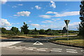
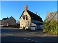
Sandpit Road at the junction of Banbury Road
Image: © David Howard
Taken: 13 Jun 2020
0.04 miles
10
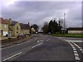
Old A421 at Finmere
The old A421 at Finmere near Little Tingewick. The Red Lion can be seen centre left and the road to the right goes to Bicester. (Many years ago, this was a T-junction where traffic from Bicester and the Sunday market at Finmere airfield waited patiently trying to turn on to what was then the busy A421.)
Image: © mick finn
Taken: 15 Nov 2008
0.05 miles