IMAGES TAKEN NEAR TO
Banbury Road, BUCKINGHAM, MK18 4AQ
Introduction
This page details the photographs taken nearby to Banbury Road, MK18 4AQ by members of the Geograph project.
The Geograph project started in 2005 with the aim of publishing, organising and preserving representative images for every square kilometre of Great Britain, Ireland and the Isle of Man.

There are currently over 7.5m images from over14,400 individuals and you can help contribute to the project by visiting https://www.geograph.org.uk
Image Map
Images are licensed for reuse under creativecommons.org/licenses/by-sa/2.0
Notes
- Clicking on the map will re-center to the selected point.
- The higher the marker number, the further away the image location is from the centre of the postcode.
Image Listing (16 Images Found)
Images are licensed for reuse under creativecommons.org/licenses/by-sa/2.0
Image
Details
Distance
1
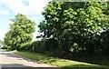
The B4031, Finmere
It's a very short B road, under half a mile.
Image: © David Howard
Taken: 13 Jun 2020
0.13 miles
2
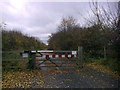
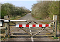
Gated Road, Finmere
Gated access to a section of the former A421 at Finmere.
Image: © mick finn
Taken: 15 Nov 2008
0.14 miles
3
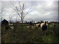
Stile and Ponies, Finmere
Inquisitive ponies gather near a stile in the corner of a field on the former A421 at Finmere.
Image: © mick finn
Taken: 15 Nov 2008
0.14 miles
4
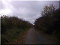
Former A421 at Finmere
Looking westwards along a section of the former A421 at Finmere.
Image: © mick finn
Taken: 15 Nov 2008
0.14 miles
5
Former main road, Finmere
The A421 now bypasses both Tingewick and Finmere.
Image: © Robin Webster
Taken: 4 Dec 2016
0.16 miles
7
The old main road at Finmere
The A421 now bypasses the village and the old road is a cycle track.
Image: © Martin Loader
Taken: 8 Apr 2007
0.17 miles
8
Triangular Junction, Finmere
Triangular green with a fine, bare tree at the junction of Valley and Mere Roads, Finmere.
Image: © mick finn
Taken: 15 Nov 2008
0.18 miles
9
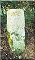
Old Milestone in Finmere
Aynho pillar by the UC road, in parish of Finmere (Cherwell District), West edge of Finmere Village, opposite boundary fence of school, under tree at back of grass verge.
Oxfordshire HER.
HER Number: 10253 https://www.heritagegateway.org.uk/Gateway/Results_Single.aspx?uid=MOX4785&resourceID=1033
Surveyed
Milestone Society National ID: OX_lc61
Image: © Milestone Society
Taken: Unknown
0.18 miles
10
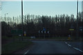
Aylesbury Vale : The A421
The A421 approaches a roundabout.
Image: © Lewis Clarke
Taken: 18 Mar 2019
0.19 miles