IMAGES TAKEN NEAR TO
Banbury Road, BUCKINGHAM, MK18 4AJ
Introduction
This page details the photographs taken nearby to Banbury Road, MK18 4AJ by members of the Geograph project.
The Geograph project started in 2005 with the aim of publishing, organising and preserving representative images for every square kilometre of Great Britain, Ireland and the Isle of Man.

There are currently over 7.5m images from over14,400 individuals and you can help contribute to the project by visiting https://www.geograph.org.uk
Image Map
Images are licensed for reuse under creativecommons.org/licenses/by-sa/2.0
Notes
- Clicking on the map will re-center to the selected point.
- The higher the marker number, the further away the image location is from the centre of the postcode.
Image Listing (6 Images Found)
Images are licensed for reuse under creativecommons.org/licenses/by-sa/2.0
Image
Details
Distance
1
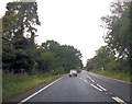
Road to Warren Farm
Road to Warren Farm
Image: © Shaun Ferguson
Taken: 12 Jun 2007
0.09 miles
2

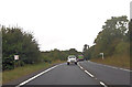
Cherwell : The A421
The A421 heading through the Cherwell District.
Image: © Lewis Clarke
Taken: 18 Mar 2019
0.18 miles
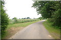
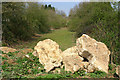
4
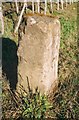
Old Milestone by the A421, west of Finmere
Aynho pillar by the A421, in parish of Finmere (Cherwell District), near old railway bridge, Mixbury Plantation, near turn to Widmore Farm, on new verge by hedge where road has been built beside old bridge.
Inscription once read:-
: (Buckingham / 5) : : (Banbury / 13) :
Carved benchmark recorded.
Oxfordshire HER.
HER Number: 10254 https://www.heritagegateway.org.uk/Gateway/Results_Single.aspx?uid=MOX4786&resourceID=1033
Surveyed
Milestone Society National ID: OX_lc62
Image: © Milestone Society
Taken: Unknown
0.21 miles
5
Disused railway near Finmere
The closed Great Central Railway, looking towards the A421 from the infilled tunnel.
Image: © Martin Loader
Taken: 8 Apr 2007
0.21 miles