IMAGES TAKEN NEAR TO
North End Road, BUCKINGHAM, MK18 2PG
Introduction
This page details the photographs taken nearby to North End Road, MK18 2PG by members of the Geograph project.
The Geograph project started in 2005 with the aim of publishing, organising and preserving representative images for every square kilometre of Great Britain, Ireland and the Isle of Man.

There are currently over 7.5m images from over14,400 individuals and you can help contribute to the project by visiting https://www.geograph.org.uk
Image Map
Images are licensed for reuse under creativecommons.org/licenses/by-sa/2.0
Notes
- Clicking on the map will re-center to the selected point.
- The higher the marker number, the further away the image location is from the centre of the postcode.
Image Listing (12 Images Found)
Images are licensed for reuse under creativecommons.org/licenses/by-sa/2.0
Image
Details
Distance
1
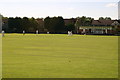
Cricket ground Steeple Claydon
Cricket ground at Steeple Claydon with the match stopping for tea
Image: © Shaun Ferguson
Taken: 7 Jul 2007
0.04 miles
2
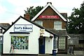
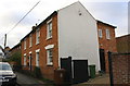
Karl's Bakery by the Fountain on West Street
Image: © Steve Daniels
Taken: 1 Jul 2014
0.14 miles
3
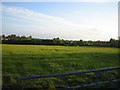
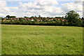
Field and edge of village, Steeple Claydon 2
This view to the south-west from the lane that runs round the north of Steeple Claydon shows in the centre, part of the northern edge of Steeple Claydon across a field. On the right, amidst trees, are the houses of North End on the western side of the village, see also Image
Image: © Andy Gryce
Taken: 12 May 2007
0.14 miles
4
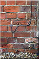
Benchmark on #5 Chaloners Hill
Ordnance Survey cut mark benchmark described on the Bench Mark Database at http://www.bench-marks.org.uk/bm82538
Image: © Roger Templeman
Taken: 2 Mar 2017
0.15 miles
5
The Cottage, #5 Chaloners Hill
There is an OS benchmark Image on the front of the house at the near corner
Image: © Roger Templeman
Taken: 2 Mar 2017
0.16 miles
6
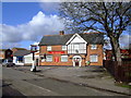
Fountain Inn, Steeple Claydon
In new 2007 livery
Image: © al partington
Taken: 7 Mar 2007
0.19 miles
7
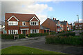
Nightingale Fold, Steeple Claydon (1)
Nightingale Fold is a very recent development by Bovis Homes and borders North End Road. This shows Welford Close as seen from Mitchinson Street. All four roads on the development are named after local councillors, the other two being Becketts Lane and Hobbs Close.
Image: © David Kemp
Taken: 22 Nov 2020
0.21 miles
8

Nightingale Fold, Steeple Claydon (2)
Nightingale Fold is a very recent development by Bovis Homes and borders North End Road. All four roads on the development - Mitchinson Street, Hobbs Close, Welford Close and Becketts Lane - are named after local councillors. This shows houses in Becketts Lane as seen from the corner of Welford Close.
Image: © David Kemp
Taken: 22 Nov 2020
0.22 miles
9

Telephone Exchange, Steeple Claydon
Situated in West Street, MK18 2NT, this TE provides telephone and broadband services to Steeple Claydon, in addition to Calvert, Charndon, Hillesden, Middle Claydon and Twyford nearby. Both buildings would appear to date from the GPO era, although the white notices at the front clearly indicate that they now belong to BT. The rear nearside of a BT Openreach vehicle can be seen on the extreme left of the photo.
Image: © David Hillas
Taken: 9 Apr 2010
0.24 miles
10
Nearing Steeple Claydon
The Bernwood Way nearing Steeple Claydon
Image: © Shaun Ferguson
Taken: 7 Jul 2007
0.25 miles