IMAGES TAKEN NEAR TO
Verney Junction, BUCKINGHAM, MK18 2JY
Introduction
This page details the photographs taken nearby to MK18 2JY by members of the Geograph project.
The Geograph project started in 2005 with the aim of publishing, organising and preserving representative images for every square kilometre of Great Britain, Ireland and the Isle of Man.

There are currently over 7.5m images from over14,400 individuals and you can help contribute to the project by visiting https://www.geograph.org.uk
Image Map
Images are licensed for reuse under creativecommons.org/licenses/by-sa/2.0
Notes
- Clicking on the map will re-center to the selected point.
- The higher the marker number, the further away the image location is from the centre of the postcode.
Image Listing (16 Images Found)
Images are licensed for reuse under creativecommons.org/licenses/by-sa/2.0
Image
Details
Distance
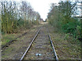
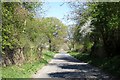
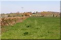
2
East of Verney Junction
On the left is the disused Metropolitan Line as it curves left to Verney Junction. The line ran from this station to Baker Street, London. On the right is the disused Varsity Line (Oxford to Cambridge) which was joined by the Metropolitan line just beyond this photo on the approach to Verney Junction. East West Rail will reopen the line between Oxford and Bletchley with twin tracks by December 2017. It is also scheduled to reopen the line from Aylesbury to Claydon at the same time. Trains will then run from Aylesbury to Milton Keynes as well as between other destinations. More details http://www.eastwestrail.org.uk
Image: © Andrew Bodman
Taken: 24 Mar 2014
0.13 miles
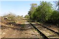
3
Disused Railway Lines
Here, the course of the Quainton Road to Verney Junction branch (now lifted) can be seen running in parallel with the main line railway (now also disused) just outside Verney Junction station.
Image: © Hywel Williams
Taken: 25 Mar 2005
0.14 miles
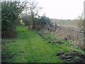
4
Railway east of Verney Junction level crossing, 2014
Vegetation clearance has been carried out recently on the mothballed line.
Image: © Robin Webster
Taken: 22 Feb 2014
0.17 miles
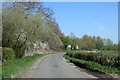
5
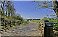
The road to Winslow
The supports for the former bridge on the line to Quainton Road can be seen on either side of the road.
Image: © Steve Daniels
Taken: 21 Apr 2015
0.18 miles
6
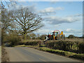
Verney Road approaching former railway bridge
In the dip, the road passed under the former Metropolitan Line route from Quainton Road to Verney Junction. This finally closed for freight in 1947, although here used as a long siding until 1961. The lorry with a digger is at the start of a farm track that bends up onto and along the old trackbed.
Image: © Robin Webster
Taken: 22 Feb 2014
0.19 miles
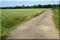
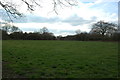
10
The former line to Bletchley
The East West Railway is being reinstated between Oxford and Bletchley.
Image: © Steve Daniels
Taken: 21 Apr 2015
0.23 miles