IMAGES TAKEN NEAR TO
Ford Street, BUCKINGHAM, MK18 1UP
Introduction
This page details the photographs taken nearby to Ford Street, MK18 1UP by members of the Geograph project.
The Geograph project started in 2005 with the aim of publishing, organising and preserving representative images for every square kilometre of Great Britain, Ireland and the Isle of Man.

There are currently over 7.5m images from over14,400 individuals and you can help contribute to the project by visiting https://www.geograph.org.uk
Image Map
Images are licensed for reuse under creativecommons.org/licenses/by-sa/2.0
Notes
- Clicking on the map will re-center to the selected point.
- The higher the marker number, the further away the image location is from the centre of the postcode.
Image Listing (177 Images Found)
Images are licensed for reuse under creativecommons.org/licenses/by-sa/2.0
Image
Details
Distance
1
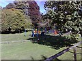
Tot's Corner, Buckingham
A small playground for young children on the banks of the Ouse near Bridge St, Buckingham.
Image: © mick finn
Taken: 11 Oct 2008
0.01 miles
2
Footbridge over the Ouse
The footbridge which crosses the Ouse at Bridge St, Buckingham. It is adjacent to the old road bridge.
Image: © mick finn
Taken: 11 Oct 2008
0.01 miles
3
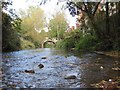
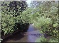
River Great Ouse in Buckingham
This is a kingfisher's eye view along the shallow bed of the River Great Ouse from Image towards the London Bridge. On the right is the Coopers Wharf residential development which from 1834 was the site of Buckingham Gasworks.
Image: © Nigel Cox
Taken: 17 Oct 2010
0.01 miles
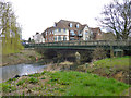
4
Bridgeworks over the Great Ouse, Buckingham
Image: © David Howard
Taken: 4 Feb 2018
0.01 miles
5
The New Inn, Buckingham
Greene King pub
Image: © al partington
Taken: 18 Feb 2008
0.01 miles
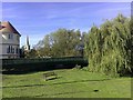
6
SW parapet of London Bridge, Bridge Street over the Great Ouse
Photo taken across Bridge Street from the pedestrian bridge.
Image: © Roger Templeman
Taken: 17 Feb 2011
0.02 miles
7
London Bridge, Buckingham
The route out of town to London crosses the Great Ouse.
Image: © Robin Webster
Taken: 27 Mar 2015
0.02 miles
8
River Ouse from Ford Street
Looking northeast from the footbridge crossing the river at Ford Street. In the centre, the arch of 'London Bridge' can be seen reflected in the water.
Image: © mick finn
Taken: 25 May 2009
0.02 miles
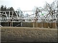
9
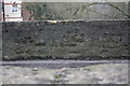
Buckingham: London Bridge
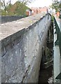
London Bridge was largely funded by the 1st Marquis of Buckingham to provide a better approach to the town from the south than Image The bridge was completed in 1805, of coursed limestone and limestone ashlar, with three elliptical arches, which are just visible in the photograph here. The bridge and its causeway to the north now form a Grade II Listed Structure.
An overall clear view of the whole bridge crossing the River Great Ouse is nigh on impossible these days with the modern footbridge to the right running parallel, close, and at about the same height. However the footbridge does now afford a close up view of the tablet containing the coat of arms of the Marquis of Buckingham in the centre of the downstream side here. The coat of arms, complete with supporters and marquis' coronet, has the impressed mark Coade & Seely, Lambeth, and is dated 1805. It is curious that such effort went into producing this tablet when in 1805 it would have been out of close up sight to all and sundry. Perhaps the designers were prescient enough to foresee 20th century traffic, and the need for a separate pedestrian walkway!
Image: © Nigel Cox
Taken: 17 Oct 2010
0.03 miles
10
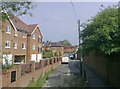
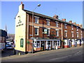
Ford Street, Buckingham
Ford Street viewed from the footbridge over the Ouse. The recently-built flats to the left are known as 'Cooper's Wharf'. In the 19th century, a gasworks occupied the site.
Image: © mick finn
Taken: 25 May 2009
0.03 miles