IMAGES TAKEN NEAR TO
Fishers Field, BUCKINGHAM, MK18 1SN
Introduction
This page details the photographs taken nearby to Fishers Field, MK18 1SN by members of the Geograph project.
The Geograph project started in 2005 with the aim of publishing, organising and preserving representative images for every square kilometre of Great Britain, Ireland and the Isle of Man.

There are currently over 7.5m images from over14,400 individuals and you can help contribute to the project by visiting https://www.geograph.org.uk
Image Map
Images are licensed for reuse under creativecommons.org/licenses/by-sa/2.0
Notes
- Clicking on the map will re-center to the selected point.
- The higher the marker number, the further away the image location is from the centre of the postcode.
Image Listing (138 Images Found)
Images are licensed for reuse under creativecommons.org/licenses/by-sa/2.0
Image
Details
Distance
1
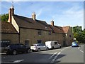
Castle House
14th Century house in West Street. Probably takes its name from Castle Farm and Castle Farm which were nearby.
http://www.buckingham-tc.gov.uk/
Image: © Colin Smith
Taken: 2 Jan 2010
0.05 miles
4
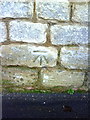
Benchmark on former school on west side of School Lane
Ordnance Survey cut mark benchmark described on the Bench Mark Database at http://www.bench-marks.org.uk/bm36923
Image: © Roger Templeman
Taken: 11 Feb 2011
0.08 miles
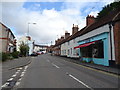
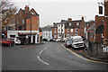
5
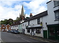
Shop and houses on Nelson Street, Buckingham
Image: © JThomas
Taken: 28 Sep 2019
0.09 miles
6
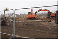
Demolition on the site of Castle Mill
I think this used to be Hamilton Precision but the site is destined to have more housing.
Image: © Bill Boaden
Taken: 24 Nov 2018
0.09 miles
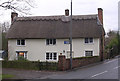
7
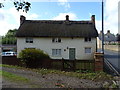
Thatched cottage on the West Street, Buckingham
Image: © JThomas
Taken: 28 Sep 2019
0.09 miles
8
Nelson Street
An old but now lesser used route from the town centre, as seen from Castle Street.
Image: © Bill Boaden
Taken: 24 Nov 2018
0.10 miles
9
Tollhouse by the A422, West Street, Buckingham
Tollhouse in the parish of Buckingham (Aylesbury Vale District), No. 14, West Street, MK18 1HP.
Grade II listed.
List Entry Number: 1282696 https://historicengland.org.uk/listing/the-list/list-entry/1282696
Surveyed
Milestone Society National ID: BU.BUC
Image: © Alan Rosevear
Taken: Unknown
0.10 miles