IMAGES TAKEN NEAR TO
Moreton Road, BUCKINGHAM, MK18 1PP
Introduction
This page details the photographs taken nearby to Moreton Road, MK18 1PP by members of the Geograph project.
The Geograph project started in 2005 with the aim of publishing, organising and preserving representative images for every square kilometre of Great Britain, Ireland and the Isle of Man.

There are currently over 7.5m images from over14,400 individuals and you can help contribute to the project by visiting https://www.geograph.org.uk
Image Map
Images are licensed for reuse under creativecommons.org/licenses/by-sa/2.0
Notes
- Clicking on the map will re-center to the selected point.
- The higher the marker number, the further away the image location is from the centre of the postcode.
Image Listing (4 Images Found)
Images are licensed for reuse under creativecommons.org/licenses/by-sa/2.0
Image
Details
Distance
1
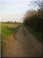
Public Bridleway
This bridleway runs from Chackmore to Buckingham Rugby Club. Looking in the direction of the rugby club, the first half of the bridleway is tarmaced road providing access to Chackmore Farm.
Image: © Mr Biz
Taken: 6 Apr 2007
0.15 miles
2
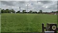
Path heads across the Buckingham Rugby Club pitches
Path heads across the Buckingham Rugby Club pitches heading up past the mobile mast
Image: © Shaun Ferguson
Taken: 7 Jun 2021
0.18 miles
3
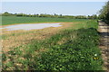
Big puddle by the bridleway into Maids Moreton
Image: © Philip Jeffrey
Taken: 7 May 2018
0.19 miles
4
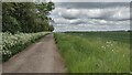
Track heading to Chackmore
From the Buckingham Rugby Club the track heading to Chackmore
Image: © Shaun Ferguson
Taken: 7 Jun 2021
0.19 miles