IMAGES TAKEN NEAR TO
Woodlands Crescent, BUCKINGHAM, MK18 1PJ
Introduction
This page details the photographs taken nearby to Woodlands Crescent, MK18 1PJ by members of the Geograph project.
The Geograph project started in 2005 with the aim of publishing, organising and preserving representative images for every square kilometre of Great Britain, Ireland and the Isle of Man.

There are currently over 7.5m images from over14,400 individuals and you can help contribute to the project by visiting https://www.geograph.org.uk
Image Map
Images are licensed for reuse under creativecommons.org/licenses/by-sa/2.0
Notes
- Clicking on the map will re-center to the selected point.
- The higher the marker number, the further away the image location is from the centre of the postcode.
Image Listing (24 Images Found)
Images are licensed for reuse under creativecommons.org/licenses/by-sa/2.0
Image
Details
Distance
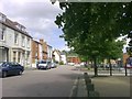
2
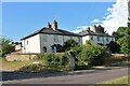
View across Moreton Road from Woodlands Crescent to Bradfield Avenue
Image: © Roger Templeman
Taken: 11 Feb 2011
0.10 miles
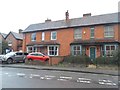
5
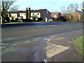
North End, Buckingham
View of North End Square from the old cattle market. The bus stand is beyond the turning and the building to the left with the arched driveway is the old Masonic Hall.
Image: © mick finn
Taken: 16 May 2009
0.18 miles
6
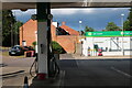
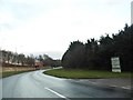
Petrol station on Stratford Road, Buckingham
Image: © David Howard
Taken: 13 Jun 2020
0.19 miles
8
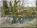
Broken weir, River Great Ouse
Or so it seems, but a weir has never been mapped here.
Image: © Robin Webster
Taken: 27 Mar 2015
0.20 miles
9
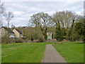
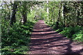
Path south of River Great Ouse, Buckingham
Through an open space or park that extends some way along the river.
Image: © Robin Webster
Taken: 27 Mar 2015
0.20 miles
10
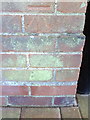
Benchmark on #1 Overn Avenue
Ordnance Survey cut mark benchmark described on the Bench Mark Database at http://www.bench-marks.org.uk/bm36905
Image: © Roger Templeman
Taken: 11 Feb 2011
0.20 miles