IMAGES TAKEN NEAR TO
Glynswood Road, BUCKINGHAM, MK18 1JF
Introduction
This page details the photographs taken nearby to Glynswood Road, MK18 1JF by members of the Geograph project.
The Geograph project started in 2005 with the aim of publishing, organising and preserving representative images for every square kilometre of Great Britain, Ireland and the Isle of Man.

There are currently over 7.5m images from over14,400 individuals and you can help contribute to the project by visiting https://www.geograph.org.uk
Image Map
Images are licensed for reuse under creativecommons.org/licenses/by-sa/2.0
Notes
- Clicking on the map will re-center to the selected point.
- The higher the marker number, the further away the image location is from the centre of the postcode.
Image Listing (56 Images Found)
Images are licensed for reuse under creativecommons.org/licenses/by-sa/2.0
Image
Details
Distance

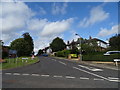
3
Stowe Avenue junction from Brackley road
Image: © John Firth
Taken: 22 Sep 2012
0.05 miles
4
Buckingham Lodges, Stowe
Built "before 1809" according to the entry in British Listed Buildings. See http://www.britishlistedbuildings.co.uk/en-377242-buckingham-lodges-west-lodge-buckingham-#.Vd7OH_lViko.
Image: © Bikeboy
Taken: 20 Aug 2015
0.06 miles
5
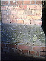
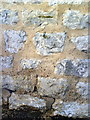
Benchmark on wall pier at SE corner of cemetery, Brackley Road
Ordnance Survey cut mark benchmark described on the Bench Mark Database at http://www.bench-marks.org.uk/bm36915
Image: © Roger Templeman
Taken: 11 Feb 2011
0.06 miles
6
Benchmark on Avenue House, West Street
Ordnance Survey cut mark benchmark described on the Bench Mark Database at http://www.bench-marks.org.uk/bm36919
Image: © Roger Templeman
Taken: 11 Feb 2011
0.06 miles

8
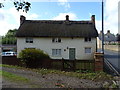
Thatched cottage on the West Street, Buckingham
Image: © JThomas
Taken: 28 Sep 2019
0.10 miles
9
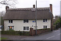
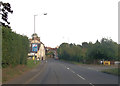
Tollhouse by the A422, West Street, Buckingham
Tollhouse in the parish of Buckingham (Aylesbury Vale District), No. 14, West Street, MK18 1HP.
Grade II listed.
List Entry Number: 1282696 https://historicengland.org.uk/listing/the-list/list-entry/1282696
Surveyed
Milestone Society National ID: BU.BUC
Image: © Alan Rosevear
Taken: Unknown
0.10 miles
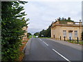
10
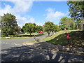
Junction of West Street and Western Avenue, Buckingham
Showing position of Postbox No. MK18 175.
See Image] for postbox.
Image: © JThomas
Taken: 28 Sep 2019
0.10 miles