IMAGES TAKEN NEAR TO
Minshull Close, BUCKINGHAM, MK18 1JE
Introduction
This page details the photographs taken nearby to Minshull Close, MK18 1JE by members of the Geograph project.
The Geograph project started in 2005 with the aim of publishing, organising and preserving representative images for every square kilometre of Great Britain, Ireland and the Isle of Man.

There are currently over 7.5m images from over14,400 individuals and you can help contribute to the project by visiting https://www.geograph.org.uk
Image Map
Images are licensed for reuse under creativecommons.org/licenses/by-sa/2.0
Notes
- Clicking on the map will re-center to the selected point.
- The higher the marker number, the further away the image location is from the centre of the postcode.
Image Listing (136 Images Found)
Images are licensed for reuse under creativecommons.org/licenses/by-sa/2.0
Image
Details
Distance
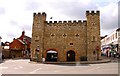
1
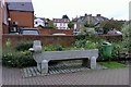
Horse trough, Buckingham
Horse trough near the Community Centre, Buckingham. The old Masonic Hall can be seen in the middle distance (the white building) and the Grand Junction PH is right of centre.
Image: © mick finn
Taken: 6 Oct 2008
0.10 miles
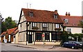
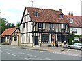
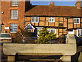
4
Former King's Head, Buckingham
Fine old half-timbered building on the High Street. Plastering has been removed, revealing half-timbering and the jettied upper floor. Recently the old inn has housed a series of restaurants.
http://www.buckingham-tc.gov.uk/
Image: © Colin Smith
Taken: 2 Jan 2010
0.10 miles
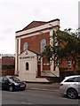
5
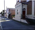
Salvation Army Citadel
The Salvation Army citadel in Moreton Rd, Buckingham.
Image: © mick finn
Taken: 12 Oct 2008
0.10 miles
6
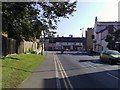
Moreton Rd, Buckingham
Looking south along Moreton Road in Buckingham. Cornwall's Meadow and Meadow Walk lie behind the buildings in the distance.
Image: © mick finn
Taken: 12 Oct 2008
0.10 miles
7
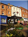
Market Square
Saturday Market stalls occupy space in the wide square which is now lined by pubs and shops.
http://www.buckingham-tc.gov.uk/
Image: © Colin Smith
Taken: 2 Jan 2010
0.11 miles
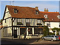
8
The Tudor Rock
The Tudor Rock, Buckingham, on the corner on Moreton Road.
Image: © Snidge
Taken: 28 Jun 2007
0.11 miles
10
Cattle Trough, High Street
The trough carries a date of 1904 and sits in an island within the wide High Street of Buckingham. This street was formerly called the Cow Fair and is lined by old cottages and inns.
http://www.buckingham-tc.gov.uk/
Image: © Colin Smith
Taken: 2 Jan 2010
0.11 miles