IMAGES TAKEN NEAR TO
Lenborough Road, BUCKINGHAM, MK18 1HR
Introduction
This page details the photographs taken nearby to Lenborough Road, MK18 1HR by members of the Geograph project.
The Geograph project started in 2005 with the aim of publishing, organising and preserving representative images for every square kilometre of Great Britain, Ireland and the Isle of Man.

There are currently over 7.5m images from over14,400 individuals and you can help contribute to the project by visiting https://www.geograph.org.uk
Image Map
Images are licensed for reuse under creativecommons.org/licenses/by-sa/2.0
Notes
- Clicking on the map will re-center to the selected point.
- The higher the marker number, the further away the image location is from the centre of the postcode.
Image Listing (42 Images Found)
Images are licensed for reuse under creativecommons.org/licenses/by-sa/2.0
Image
Details
Distance
1
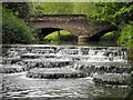
The 'Flosh' & Lords Bridge, Buckingham
This weir on the River Ouse is upstream of Town Mill. The road crossing the Lords Bridge is Hunter Street which leads to the 'prebend end beyond the water'. The weir and mill are within Buckingham University's Hunter Street campus and the mill has been renamed Tanlaw Mill.
Image: © Mark R Dornan
Taken: 23 May 2009
0.05 miles
2
Weir on the Ouse
A weir on the river Ouse alongside Station Rd, Buckingham.
Image: © mick finn
Taken: 11 Oct 2008
0.05 miles
3
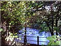
Buckingham: Former railway station (2)
The photographer is standing in the middle of the railway trackbed at the former Buckingham railway station, as seen in Ben Brooksbank's Image from 48 years previously. The low platform edges are all that remain and can be seen here to left and right.
Image: © Nigel Cox
Taken: 17 Oct 2010
0.06 miles
4
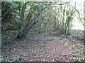
Buckingham: Former railway station (1)
The photographer has tried to re-occupy the same viewpoint on the platform edge of Buckingham station where Ben Brooksbank stood over 48 years ago Image The old platform edge is covered in ivy in the bottom right of the photograph. 46 years after closure and nature has almost completely reclaimed the site.
Image: © Nigel Cox
Taken: 17 Oct 2010
0.06 miles
5
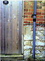
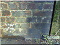
Benchmark on #10 Lenborough Road
Ordnance Survey cut mark benchmark described on the Bench Mark Database at http://www.bench-marks.org.uk/bm37042
Image: © Roger Templeman
Taken: 17 Feb 2011
0.07 miles
7
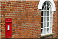
Victorian Postbox on the wall of the University of Buckingham
Image: © Philip Jeffrey
Taken: 13 Jan 2013
0.08 miles
9
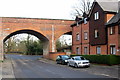
Benchmark on railway bridge, Hunter Street
Ordnance Survey cut mark benchmark described on the Bench Mark Database at http://www.bench-marks.org.uk/bm37040
Image: © Roger Templeman
Taken: 17 Feb 2011
0.09 miles
10
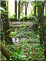
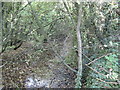
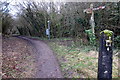
Old Railway Platform
The old railway.
Image: © Maddie Hooper
Taken: 5 Oct 2008
0.09 miles