IMAGES TAKEN NEAR TO
Nelson Street, BUCKINGHAM, MK18 1GW
Introduction
This page details the photographs taken nearby to Nelson Street, MK18 1GW by members of the Geograph project.
The Geograph project started in 2005 with the aim of publishing, organising and preserving representative images for every square kilometre of Great Britain, Ireland and the Isle of Man.

There are currently over 7.5m images from over14,400 individuals and you can help contribute to the project by visiting https://www.geograph.org.uk
Image Map
Images are licensed for reuse under creativecommons.org/licenses/by-sa/2.0
Notes
- Clicking on the map will re-center to the selected point.
- The higher the marker number, the further away the image location is from the centre of the postcode.
Image Listing (143 Images Found)
Images are licensed for reuse under creativecommons.org/licenses/by-sa/2.0
Image
Details
Distance
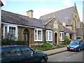
1
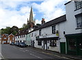
Shop and houses on Nelson Street, Buckingham
Image: © JThomas
Taken: 28 Sep 2019
0.01 miles
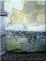
3
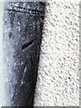
Benchmark on wall of Tingewick Road behind salt grit bin.
Ordnance Survey cut mark benchmark described on the Bench Mark Database at http://www.bench-marks.org.uk/bm37043
Image: © Roger Templeman
Taken: 17 Feb 2011
0.02 miles
4
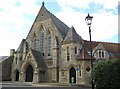
Buckingham: The Radcliffe Centre
The Radcliffe Centre in Church Street was built as a Congregational Chapel and completed in 1857 to the designs of Foster and Wood of Bristol. It was enlarged in 1879 by the addition of a Sunday School, being the extension to the right with the red tiled roof. It later became surplus to requirements, was bought by The University of Buckingham in 1982 and converted into a lecture and concert venue.
Image: © Nigel Cox
Taken: 17 Oct 2010
0.04 miles
5
Buckingham: Barton's Hospital
Barton's Hospital is a group of six almshouses in Church Street founded under the will of John Barton in 1431. Under the terms of the will, the charity provided a dwelling place and fourpence a week to six poor men or women so long as they prayed daily for the soul of the late John Barton.
The almshouses were rebuilt in 1910. The slate roof of the main hall of Image is visible to the right.
Image: © Nigel Cox
Taken: 17 Oct 2010
0.04 miles
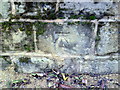
6
Benchmark on the east face of the tower of St Peter & St Paul's Church
Ordnance Survey cut mark benchmark described on the Bench Mark Database at http://www.bench-marks.org.uk/bm36924
Image: © Roger Templeman
Taken: 11 Feb 2011
0.06 miles
7

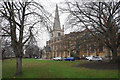
St Peter & St Paul Parish Church and Church Street
The Danish Vikings conquered the North of England and attacked southern England many times. King Edward, son of Alfred the Great, came to Buckingham about 915 and built a fort on Castle Hill. There was also a short lived wooden castle erected in 1215 and torn down again after about 30 years. This site is now covered by the Parish Church. The foundation stone for the new church was laid by Robert Bartlett, bailiff of Buckingham, on 25 November 1777.
Image: © Matthew Hatton
Taken: 21 Dec 2012
0.06 miles
8
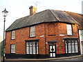
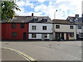
Red Brick Buckingham
Distinctive old house at the corner of Church and Well Streets.
http://www.buckingham-tc.gov.uk/
Image: © Colin Smith
Taken: 2 Jan 2010
0.06 miles
9
Benchmark on wall at junction of Hunter Street and Manor Street
Ordnance Survey cut mark benchmark described on the Bench Mark Database at http://www.bench-marks.org.uk/bm37041
Image: © Roger Templeman
Taken: 17 Feb 2011
0.06 miles
10
Buckingham Parish Church
The Church of St Peter & St Paul, but it presents itself as BPC. The building dates from 1780 and replaces an earlier church further down the hill.
Image: © Bill Boaden
Taken: 24 Nov 2018
0.06 miles