IMAGES TAKEN NEAR TO
Candleford Court, BUCKINGHAM, MK18 1GA
Introduction
This page details the photographs taken nearby to Candleford Court, MK18 1GA by members of the Geograph project.
The Geograph project started in 2005 with the aim of publishing, organising and preserving representative images for every square kilometre of Great Britain, Ireland and the Isle of Man.

There are currently over 7.5m images from over14,400 individuals and you can help contribute to the project by visiting https://www.geograph.org.uk
Image Map
Images are licensed for reuse under creativecommons.org/licenses/by-sa/2.0
Notes
- Clicking on the map will re-center to the selected point.
- The higher the marker number, the further away the image location is from the centre of the postcode.
Image Listing (182 Images Found)
Images are licensed for reuse under creativecommons.org/licenses/by-sa/2.0
Image
Details
Distance
1
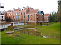
Flats, Candleford Court, Buckingham
What looks like flooding is an intentional water feature.
Image: © Robin Webster
Taken: 27 Mar 2015
0.02 miles
2
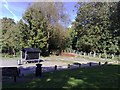
Path with footbridge at Buckingham
Pathway to footbridge over the Ouse used as a shortcut to Town from Bridge St, Buckingham. The large paved area is part of the skateboard park, built on the site of the former (disused) outdoor swimming pool.
Image: © mick finn
Taken: 11 Oct 2008
0.02 miles
3
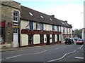
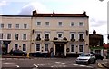
Buckingham: The Three Cups
This public house has been repainted since Al Partington's Image was taken in February 2008. It dates from the late 17th or early 18th century and is a Grade II Listed building.
Image: © Nigel Cox
Taken: 17 Oct 2010
0.03 miles
5
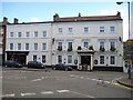
Buckingham: The White Hart Hotel
The White Hart is an early 19th century coaching inn on the Market Square and a Grade II Listed Building.
Image: © Nigel Cox
Taken: 17 Oct 2010
0.04 miles
6
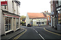
Junction of Bridge Street and Well Street, Buckingham
The corner building is grade II listed, probably late 15th century, but with later alteration.
Image: © Robin Webster
Taken: 27 Mar 2015
0.04 miles
8
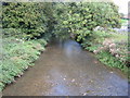
River Great Ouse in Buckingham
This is the view looking downstream from the footbridge next to London Bridge.
One of the unusual features of large scale Victorian Ordnance Survey maps was the occasional recording of the precise surface level, above sea level, of the water in a river at a prominent crossing point with the exact date that it was measured shown on the map too. Here the Ordnance Survey surveyed a height of 253.61 feet on 15 July 1879. This is 77.30 metres, and it would be interesting, as a comparison, to see what level the Environment Agency currently have for the location.
Image: © Nigel Cox
Taken: 17 Oct 2010
0.05 miles
9
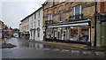
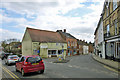
Bridge Street, Buckingham
Shops on Bridge Street.
Image: © Peter Mackenzie
Taken: 25 Nov 2019
0.05 miles
10
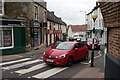
Bridge Street, Buckingham
The centre of Buckingham seems to be constantly clogged with vehicles fighting their way through the narrow streets as this view down Bridge Street illustrates.
Image: © Stephen McKay
Taken: 1 Sep 2021
0.05 miles