IMAGES TAKEN NEAR TO
Foxglove Close, BUCKINGHAM, MK18 1FU
Introduction
This page details the photographs taken nearby to Foxglove Close, MK18 1FU by members of the Geograph project.
The Geograph project started in 2005 with the aim of publishing, organising and preserving representative images for every square kilometre of Great Britain, Ireland and the Isle of Man.

There are currently over 7.5m images from over14,400 individuals and you can help contribute to the project by visiting https://www.geograph.org.uk
Image Map
Images are licensed for reuse under creativecommons.org/licenses/by-sa/2.0
Notes
- Clicking on the map will re-center to the selected point.
- The higher the marker number, the further away the image location is from the centre of the postcode.
Image Listing (29 Images Found)
Images are licensed for reuse under creativecommons.org/licenses/by-sa/2.0
Image
Details
Distance
1
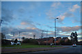
Buckingham : Embleton Way
Seen from the A421 roundabout.
Image: © Lewis Clarke
Taken: 18 Mar 2019
0.07 miles
3
Bone Hill
A longstanding footpath climbing away from Buckingham.
Image: © Bill Boaden
Taken: 24 Nov 2018
0.14 miles
4
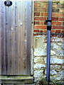
Benchmark on #10 Lenborough Road
Ordnance Survey cut mark benchmark described on the Bench Mark Database at http://www.bench-marks.org.uk/bm37042
Image: © Roger Templeman
Taken: 17 Feb 2011
0.15 miles
5
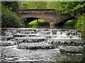
The 'Flosh' & Lords Bridge, Buckingham
This weir on the River Ouse is upstream of Town Mill. The road crossing the Lords Bridge is Hunter Street which leads to the 'prebend end beyond the water'. The weir and mill are within Buckingham University's Hunter Street campus and the mill has been renamed Tanlaw Mill.
Image: © Mark R Dornan
Taken: 23 May 2009
0.16 miles
6
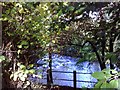
Weir on the Ouse
A weir on the river Ouse alongside Station Rd, Buckingham.
Image: © mick finn
Taken: 11 Oct 2008
0.16 miles
7
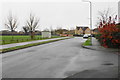
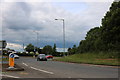
Embleton Way
Part of the residential expansion of Buckingham. It is viewed on a very dull autumn day.
Image: © Bill Boaden
Taken: 24 Nov 2018
0.16 miles
8
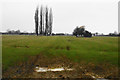
Farmland near Buckingham
On the west side of Gawcott Road. It is a very dull autumn day and just about to rain, and this is affecting the visibility.
Image: © Bill Boaden
Taken: 24 Nov 2018
0.16 miles
9
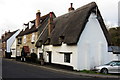
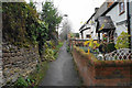
Cottage and Mitre Pub on Mitre Street
Image: © Philip Jeffrey
Taken: 13 Jan 2013
0.16 miles
10
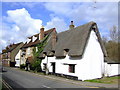
The Mitre, Buckingham
Three to four changing beers from all parts of the country in this cosy pub adjacent to the old railway viaduct. The thatched building in the foreground is Mitre Cottage - the remains of a 15 century cruck framed hall house converted in the 17th century when a 1st floor was added.
Image: © al partington
Taken: 7 Mar 2007
0.18 miles