IMAGES TAKEN NEAR TO
Waine Close, BUCKINGHAM, MK18 1FG
Introduction
This page details the photographs taken nearby to Waine Close, MK18 1FG by members of the Geograph project.
The Geograph project started in 2005 with the aim of publishing, organising and preserving representative images for every square kilometre of Great Britain, Ireland and the Isle of Man.

There are currently over 7.5m images from over14,400 individuals and you can help contribute to the project by visiting https://www.geograph.org.uk
Image Map
Images are licensed for reuse under creativecommons.org/licenses/by-sa/2.0
Notes
- Clicking on the map will re-center to the selected point.
- The higher the marker number, the further away the image location is from the centre of the postcode.
Image Listing (20 Images Found)
Images are licensed for reuse under creativecommons.org/licenses/by-sa/2.0
Image
Details
Distance
1
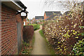
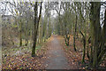
Path between the houses
A path created through new housing development.
Image: © Bill Boaden
Taken: 24 Nov 2018
0.02 miles
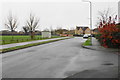
2
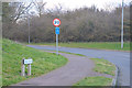
Buckingham : Embleton Way
Seen from the A421.
Image: © Lewis Clarke
Taken: 18 Mar 2019
0.11 miles
3
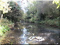
Buckingham: Former railway line now a pond
46 years after closure of the railway and the trackbed of the former Banbury to Verney Junction Branch line, just south-east of the location of the long-demolished Buckingham station, has, either by nature or design, filled up with water in a shallow cutting. The feature is now even shown as a pond on the Ordnance Survey 1:25,000 scale mapping, and is visible alongside Buckingham's Railway Walk.
Image: © Nigel Cox
Taken: 17 Oct 2010
0.12 miles
4
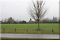
Mount Pleasant
Green space in the middle of new housing development. There is a distant view of the spire of Buckingham Parish Church. It is viewed on a dull autumn day.
Image: © Bill Boaden
Taken: 24 Nov 2018
0.14 miles
5
Path on a former railway
This was part of the London & North Western Railway line from Bletchley to Banbury. It now helps to provide good walking around Buckingham.
Image: © Bill Boaden
Taken: 24 Nov 2018
0.17 miles
6
Embleton Way
Part of the residential expansion of Buckingham. It is viewed on a very dull autumn day.
Image: © Bill Boaden
Taken: 24 Nov 2018
0.17 miles
7
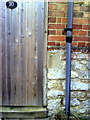
Benchmark on #10 Lenborough Road
Ordnance Survey cut mark benchmark described on the Bench Mark Database at http://www.bench-marks.org.uk/bm37042
Image: © Roger Templeman
Taken: 17 Feb 2011
0.17 miles
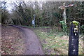
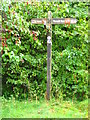
10
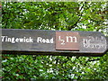
Signpost, Railway Walk, Buckingham
A signpost on railway walk.
Image: © Maddie Hooper
Taken: 5 Oct 2008
0.18 miles