IMAGES TAKEN NEAR TO
Hunter Street, BUCKINGHAM, MK18 1DQ
Introduction
This page details the photographs taken nearby to Hunter Street, MK18 1DQ by members of the Geograph project.
The Geograph project started in 2005 with the aim of publishing, organising and preserving representative images for every square kilometre of Great Britain, Ireland and the Isle of Man.

There are currently over 7.5m images from over14,400 individuals and you can help contribute to the project by visiting https://www.geograph.org.uk
Image Map
Images are licensed for reuse under creativecommons.org/licenses/by-sa/2.0
Notes
- Clicking on the map will re-center to the selected point.
- The higher the marker number, the further away the image location is from the centre of the postcode.
Image Listing (73 Images Found)
Images are licensed for reuse under creativecommons.org/licenses/by-sa/2.0
Image
Details
Distance
1
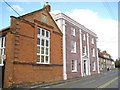
Buckingham: Yeomanry Hall & Yeomanry House
In a contrast in building styles on the left in this view looking up Hunter Street is the former Masonic Hall known as Yeomanry Hall. It was built in 1787 of English Bond red brick. On the right is Yeomanry House, the former quarters of the local Yeomanry officer, a later building dating from the early 19th century, with incised masonry patterns picked out in its dull pink render. The buildings are both Grade II Listed and now belong to The University of Buckingham.
Image: © Nigel Cox
Taken: 17 Oct 2010
0.01 miles
2
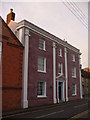
Yeomanry House, Buckingham
This house on Hunter Street became the HQ of the Royal Bucks Yeomanry but today it is part of the University of Buckingham.
http://www.buckingham-tc.gov.uk/
Image: © Colin Smith
Taken: 2 Jan 2010
0.03 miles
3
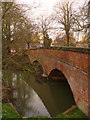
Lord's Bridge
Red brick bridge across the Ouse, leading to Hunter Street and central Buckingham.
http://www.buckingham-tc.gov.uk/
Image: © Colin Smith
Taken: 2 Jan 2010
0.04 miles
4
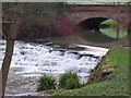
River Ouse and Lord's Bridge
View from a new signposted circular walk in Buckingham.
Image: © Colin Smith
Taken: 2 Jan 2010
0.06 miles
5
Church spire through the trees
The spire of Buckingham parish church, St.Peter and St.Paul's, in the distance, to the west of the town car park.
Image: © mick finn
Taken: 27 Sep 2008
0.06 miles
6
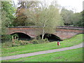
Buckingham: Lord's Bridge
Lord's Bridge carries Hunter Street over the River Great Ouse.
Image: © Nigel Cox
Taken: 17 Oct 2010
0.06 miles
7
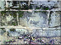
Benchmark on wall at junction of Hunter Street and Manor Street
Ordnance Survey cut mark benchmark described on the Bench Mark Database at http://www.bench-marks.org.uk/bm37041
Image: © Roger Templeman
Taken: 17 Feb 2011
0.06 miles
8
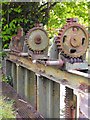
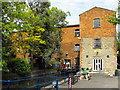
Sluice Gates, Town Mill, Buckingham
These racks are used to lift the sluice gates that control water levels in the mill race just upstream of the mill. Lifting the gates allows excess water in the race to be released back through the sluice into the River Ouse.
Image: © Mark R Dornan
Taken: 23 May 2009
0.06 miles
9
Tanlaw (formerly Old Town) Mill, Buckingham
Old Town Mill was converted in the 1980s by Buckingham University for use as student amenities and renamed Tanlaw Mill. It is adjacent to Chandos Park, southwest of the town centre.
Image: © Mark R Dornan
Taken: 23 May 2009
0.06 miles
10
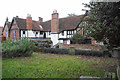
Manor House, Buckingham
A house with Tudor origins formerly linked to Lincoln Cathedral. It is viewed from the Old Churchyard, the site of the former parish church which was demolished in 1776.
Image: © Bill Boaden
Taken: 24 Nov 2018
0.07 miles