IMAGES TAKEN NEAR TO
Green End, MILTON KEYNES, MK17 9AT
Introduction
This page details the photographs taken nearby to Green End, MK17 9AT by members of the Geograph project.
The Geograph project started in 2005 with the aim of publishing, organising and preserving representative images for every square kilometre of Great Britain, Ireland and the Isle of Man.

There are currently over 7.5m images from over14,400 individuals and you can help contribute to the project by visiting https://www.geograph.org.uk
Image Map
Images are licensed for reuse under creativecommons.org/licenses/by-sa/2.0
Notes
- Clicking on the map will re-center to the selected point.
- The higher the marker number, the further away the image location is from the centre of the postcode.
Image Listing (5 Images Found)
Images are licensed for reuse under creativecommons.org/licenses/by-sa/2.0
Image
Details
Distance
1
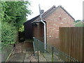
Great Brickhill Telephone Exchange
Situated in Green End, this TE shows the old and new buildings, although the wooden hut may only now be used. Its postcode is MK17 9AT.
Image: © David Hillas
Taken: 20 Jun 2009
0.03 miles
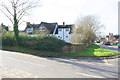
2
Benchmark on roadside wall of Pound Hill
Ordnance Survey cut mark benchmark described on the Bench Mark Database at http://www.bench-marks.org.uk/bm82651
Image: © Roger Templeman
Taken: 2 Mar 2017
0.13 miles
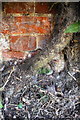
3
#40 Rotten Row at junction with Pound Hill
There is an OS benchmark Image on the corner of the wall behind ivy
Image: © Roger Templeman
Taken: 2 Mar 2017
0.13 miles
4
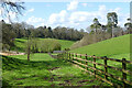
Pasture, Great Brickhill
Having descended through a wooded gully, the footpath enters pasture as it drops down to Sawpit Lane.
Image: © Andrew Smith
Taken: 30 Mar 2024
0.20 miles
5
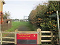
Public footpath to Great Brickhill Cricket Club
Image: © Peter S
Taken: 25 Oct 2015
0.22 miles