IMAGES TAKEN NEAR TO
Hillway, MILTON KEYNES, MK17 8UL
Introduction
This page details the photographs taken nearby to Hillway, MK17 8UL by members of the Geograph project.
The Geograph project started in 2005 with the aim of publishing, organising and preserving representative images for every square kilometre of Great Britain, Ireland and the Isle of Man.

There are currently over 7.5m images from over14,400 individuals and you can help contribute to the project by visiting https://www.geograph.org.uk
Image Map
Images are licensed for reuse under creativecommons.org/licenses/by-sa/2.0
Notes
- Clicking on the map will re-center to the selected point.
- The higher the marker number, the further away the image location is from the centre of the postcode.
Image Listing (30 Images Found)
Images are licensed for reuse under creativecommons.org/licenses/by-sa/2.0
Image
Details
Distance


9
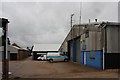
Deethe Farm Industrial Estate
Located on Cranfield Road, Woburn Sands. Home to a number of small business including, closest on the right, Moonraker Antennas.
Image: © Martin Addison
Taken: 27 May 2009
0.16 miles
10
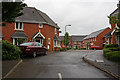
Turnpike
A new housing estate built with other housing estates in Woburn Sands.
Image: © Martin Addison
Taken: 27 May 2009
0.17 miles