IMAGES TAKEN NEAR TO
Woburn Road, MILTON KEYNES, MK17 8SZ
Introduction
This page details the photographs taken nearby to Woburn Road, MK17 8SZ by members of the Geograph project.
The Geograph project started in 2005 with the aim of publishing, organising and preserving representative images for every square kilometre of Great Britain, Ireland and the Isle of Man.

There are currently over 7.5m images from over14,400 individuals and you can help contribute to the project by visiting https://www.geograph.org.uk
Image Map
Images are licensed for reuse under creativecommons.org/licenses/by-sa/2.0
Notes
- Clicking on the map will re-center to the selected point.
- The higher the marker number, the further away the image location is from the centre of the postcode.
Image Listing (19 Images Found)
Images are licensed for reuse under creativecommons.org/licenses/by-sa/2.0
Image
Details
Distance
2
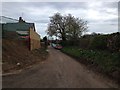
Another view of Sandy Lane
Looking back towards Woburn Sands, in the opposite direction to Image Getting a lorry down here - even the small one I was driving that day - was a tight squeeze!
Image: © John Winder
Taken: 17 Apr 2015
0.11 miles
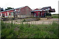
3
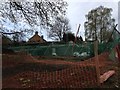
Construction on Sandy Lane
The building site referred to in Image One of two rather nice houses being built on a former field on the outskirts of Woburn Sands. The first floor has been constructed: the next step is the erection of the timber panels which will make up the second floor, and which at the time this photograph was taken, were still on the back of my lorry!
Image: © John Winder
Taken: 17 Apr 2015
0.15 miles
4

Sandy Lane, Woburn Sands
A byway, just off Woburn Sands town centre. I was here, needless to say, to deliver timber frames and wall panels to a small building site just out of shot to the right: the orange plastic fencing marks the boundary of the site which is shown on Google Earth as a field. Out of shot to the right is a small wood, and while I was waiting to be unloaded I could hear woodpeckers hammering at the trees.
Image: © John Winder
Taken: 17 Apr 2015
0.15 miles
5
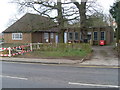
Woburn Sands Telephone Exchange (1)
Situated on the A5130 Woburn Road, the original TE on the left of the photo would appear to date from the post-war era, whilst the extension on the right would have been added somewhile later. A red rubbish container can be seen in front of the extension, whilst a black letterbox is to the left of the opened gate, although it is unlikely that it would see much post these days.
Image: © David Hillas
Taken: 17 Mar 2012
0.15 miles
6
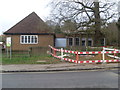
Woburn Sands Telephone Exchange (2)
This TE on the A5130 Woburn Road serves Woburn Sands plus Aspley Guise and Wavendon nearby. The wording "TELEPHONE EXCHANGE" can just be seen on the blue boarding between the original TE on the left and the extension on the right. On the left of the photo is a sign indicating that one is entering Central Bedfordshire having left Milton Keynes. This TE has (01908) 28xxxx, 58xxxx numbers, the (01908) referring to the Milton Keynes group of TEs, and its postcode is MK17 8SX.
Image: © David Hillas
Taken: 17 Mar 2012
0.15 miles
8

Woburn Road, Woburn Sands
Entering the village from the Woburn direction. The two are a fair way apart.
Image: © Robin Webster
Taken: 5 Dec 2021
0.16 miles