IMAGES TAKEN NEAR TO
Dene Close, MILTON KEYNES, MK17 8NL
Introduction
This page details the photographs taken nearby to Dene Close, MK17 8NL by members of the Geograph project.
The Geograph project started in 2005 with the aim of publishing, organising and preserving representative images for every square kilometre of Great Britain, Ireland and the Isle of Man.

There are currently over 7.5m images from over14,400 individuals and you can help contribute to the project by visiting https://www.geograph.org.uk
Image Map
Images are licensed for reuse under creativecommons.org/licenses/by-sa/2.0
Notes
- Clicking on the map will re-center to the selected point.
- The higher the marker number, the further away the image location is from the centre of the postcode.
Image Listing (26 Images Found)
Images are licensed for reuse under creativecommons.org/licenses/by-sa/2.0
Image
Details
Distance
1
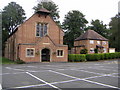
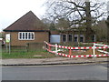
St Mary's Church, Woburn Sands
A Catholic church in Woburn Sands that seems to have been built within the last 50 years, as it doesn't show up on any '40s OS maps. To the right appears to be the father's house. In the grounds are also a meeting hall and cemetery.
Image: © Mr Biz
Taken: 13 Aug 2006
0.06 miles
2
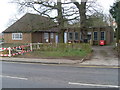
Woburn Sands Telephone Exchange (1)
Situated on the A5130 Woburn Road, the original TE on the left of the photo would appear to date from the post-war era, whilst the extension on the right would have been added somewhile later. A red rubbish container can be seen in front of the extension, whilst a black letterbox is to the left of the opened gate, although it is unlikely that it would see much post these days.
Image: © David Hillas
Taken: 17 Mar 2012
0.08 miles
3
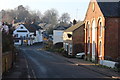
Aspley Hill
The road from Aspley Guise drops into Aspley Heath. View from just east of the junction with Downham Road.
Image: © Derek Harper
Taken: 5 Feb 2011
0.08 miles
4
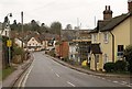
Aspley Hill at Woburn Sands
Looking down the hill into the village. The Fir Tree Inn is ahead and on the right is a converted chapel.
Image: © Robert Eva
Taken: 20 Dec 2016
0.08 miles
5
Woburn Sands Telephone Exchange (2)
This TE on the A5130 Woburn Road serves Woburn Sands plus Aspley Guise and Wavendon nearby. The wording "TELEPHONE EXCHANGE" can just be seen on the blue boarding between the original TE on the left and the extension on the right. On the left of the photo is a sign indicating that one is entering Central Bedfordshire having left Milton Keynes. This TE has (01908) 28xxxx, 58xxxx numbers, the (01908) referring to the Milton Keynes group of TEs, and its postcode is MK17 8SX.
Image: © David Hillas
Taken: 17 Mar 2012
0.08 miles
7
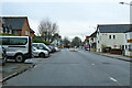
Woburn Road, Woburn Sands
Entering the village from the Woburn direction. The two are a fair way apart.
Image: © Robin Webster
Taken: 5 Dec 2021
0.11 miles
8
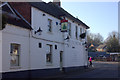
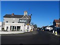
The Fir Tree Inn and High Street, Woburn Sands
Image: © Bikeboy
Taken: 16 Feb 2014
0.12 miles
9
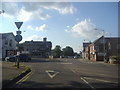
Mini roundabout on Woburn Road, Woburn Sands
Image: © David Howard
Taken: 8 Aug 2012
0.12 miles
10
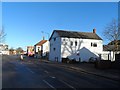
The Swan, Woburn Sands
See the sign "Buckinghamshire" below the pub sign at street level. This pub straddles the Beds/Bucks border.
Image: © Bikeboy
Taken: 16 Feb 2014
0.14 miles