IMAGES TAKEN NEAR TO
Cranfield Road, MILTON KEYNES, MK17 8BT
Introduction
This page details the photographs taken nearby to Cranfield Road, MK17 8BT by members of the Geograph project.
The Geograph project started in 2005 with the aim of publishing, organising and preserving representative images for every square kilometre of Great Britain, Ireland and the Isle of Man.

There are currently over 7.5m images from over14,400 individuals and you can help contribute to the project by visiting https://www.geograph.org.uk
Image Map
Images are licensed for reuse under creativecommons.org/licenses/by-sa/2.0
Notes
- Clicking on the map will re-center to the selected point.
- The higher the marker number, the further away the image location is from the centre of the postcode.
Image Listing (7 Images Found)
Images are licensed for reuse under creativecommons.org/licenses/by-sa/2.0
Image
Details
Distance
1
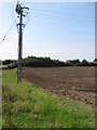
Holcotmoors Farm
The entrance and fields of Holcotmoors Farm
Image: © Richard Schmidt
Taken: 12 Nov 2006
0.02 miles
2
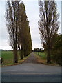
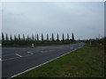
Poplar drive
The drive to Holcotmoors Farm, lined on the north side by poplars.
Image: © Richard Schmidt
Taken: 12 Nov 2006
0.10 miles
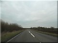
4
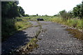
Vestige of the original road to Cranfield
Image: © Philip Jeffrey
Taken: 3 Sep 2012
0.18 miles
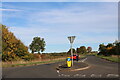
5
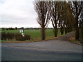
Road Junction
This junction is the path of the original road, bending off to the left. The main road continues up towards the Science park and Airport, bypassing Cranfield village.
Image: © Mr Biz
Taken: 2 Apr 2011
0.18 miles
6
Cranfield Road, Salford
This is the first time I have seen a teardrop shaped island.
Image: © David Howard
Taken: 9 Oct 2022
0.18 miles