IMAGES TAKEN NEAR TO
Stones Way, MILTON KEYNES, MK17 0LF
Introduction
This page details the photographs taken nearby to Stones Way, MK17 0LF by members of the Geograph project.
The Geograph project started in 2005 with the aim of publishing, organising and preserving representative images for every square kilometre of Great Britain, Ireland and the Isle of Man.

There are currently over 7.5m images from over14,400 individuals and you can help contribute to the project by visiting https://www.geograph.org.uk
Image Map
Images are licensed for reuse under creativecommons.org/licenses/by-sa/2.0
Notes
- Clicking on the map will re-center to the selected point.
- The higher the marker number, the further away the image location is from the centre of the postcode.
Image Listing (6 Images Found)
Images are licensed for reuse under creativecommons.org/licenses/by-sa/2.0
Image
Details
Distance
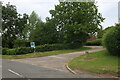
2
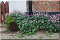
Flower bed on Main Road, Drayton Parslow
These look like geraniums.
Image: © David Howard
Taken: 18 Jun 2023
0.05 miles
4
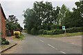
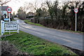
Entering Drayton Parslow on Main Road
The extra gate on the right and the speed limits have appeared since 2011
Image: © David Howard
Taken: 27 Jun 2020
0.07 miles
6
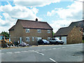
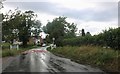
House on Main Road, Drayton Parslow
New or renovated?
Image: © Robin Webster
Taken: 25 May 2014
0.19 miles