IMAGES TAKEN NEAR TO
Main Road, MILTON KEYNES, MK17 0JS
Introduction
This page details the photographs taken nearby to Main Road, MK17 0JS by members of the Geograph project.
The Geograph project started in 2005 with the aim of publishing, organising and preserving representative images for every square kilometre of Great Britain, Ireland and the Isle of Man.

There are currently over 7.5m images from over14,400 individuals and you can help contribute to the project by visiting https://www.geograph.org.uk
Image Map
Images are licensed for reuse under creativecommons.org/licenses/by-sa/2.0
Notes
- Clicking on the map will re-center to the selected point.
- The higher the marker number, the further away the image location is from the centre of the postcode.
Image Listing (7 Images Found)
Images are licensed for reuse under creativecommons.org/licenses/by-sa/2.0
Image
Details
Distance
1
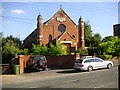
Methodist Church, Drayton Parslow
A Primitive Methodist Church built in 1912.
Image: © Mr Biz
Taken: 28 Jul 2006
0.04 miles
2
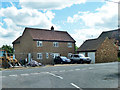
House on Main Road, Drayton Parslow
New or renovated?
Image: © Robin Webster
Taken: 25 May 2014
0.08 miles
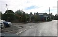
4
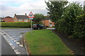
Bates Gardens, Drayton Parslow
From Main Road
Image: © David Howard
Taken: 27 Jun 2020
0.12 miles
6
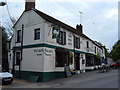
Three Horse Shoes Public House, Drayton Parslow.
The local pub in Drayton Parslow, where I sometimes have to pick my dad up from on a Sunday afternoon!
Image: © Mr Biz
Taken: 22 May 2008
0.16 miles
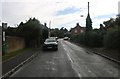
7
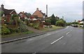
Main Road, Drayton Parslow
Looking towards the war memorial
Image: © David Howard
Taken: 27 Jun 2020
0.16 miles