IMAGES TAKEN NEAR TO
Stewkley Lane, MILTON KEYNES, MK17 0JD
Introduction
This page details the photographs taken nearby to Stewkley Lane, MK17 0JD by members of the Geograph project.
The Geograph project started in 2005 with the aim of publishing, organising and preserving representative images for every square kilometre of Great Britain, Ireland and the Isle of Man.

There are currently over 7.5m images from over14,400 individuals and you can help contribute to the project by visiting https://www.geograph.org.uk
Image Map
Images are licensed for reuse under creativecommons.org/licenses/by-sa/2.0
Notes
- Clicking on the map will re-center to the selected point.
- The higher the marker number, the further away the image location is from the centre of the postcode.
Image Listing (5 Images Found)
Images are licensed for reuse under creativecommons.org/licenses/by-sa/2.0
Image
Details
Distance
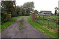
3
Stewkley Lane
A view down Stewkley Lane towards Cold Harbour and Ashdean Farm.
Image: © Mr Biz
Taken: 28 Jul 2006
0.10 miles
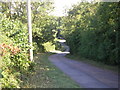
4
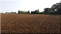
Path heading to Stewkley Lane
Path heading across ploughed field to Stewkley Lane
Image: © Shaun Ferguson
Taken: 14 Sep 2020
0.13 miles