IMAGES TAKEN NEAR TO
Newton Road, MILTON KEYNES, MK17 0EB
Introduction
This page details the photographs taken nearby to Newton Road, MK17 0EB by members of the Geograph project.
The Geograph project started in 2005 with the aim of publishing, organising and preserving representative images for every square kilometre of Great Britain, Ireland and the Isle of Man.

There are currently over 7.5m images from over14,400 individuals and you can help contribute to the project by visiting https://www.geograph.org.uk
Image Map
Images are licensed for reuse under creativecommons.org/licenses/by-sa/2.0
Notes
- Clicking on the map will re-center to the selected point.
- The higher the marker number, the further away the image location is from the centre of the postcode.
Image Listing (6 Images Found)
Images are licensed for reuse under creativecommons.org/licenses/by-sa/2.0
Image
Details
Distance
2
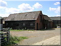
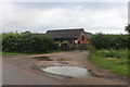
Rectory Farm
One of the brick out buildings at Rectory Farm, at the Newton Longville - Stoke Hammond crossroads.
Image: © Mr Biz
Taken: 30 Jul 2006
0.04 miles
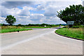
3
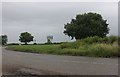
Junction on Newton Road, Stoke Hammond
Crossing Drayton Road opposite.
Image: © David Howard
Taken: 27 Jun 2020
0.05 miles
5
Staggered Crossroads near Rectory Farm, near Bletchley
Image: © Cameraman
Taken: 29 Jun 2011
0.06 miles
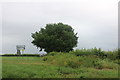
6
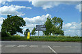
Newton Road meets the Drayton Parslow - Bletchley road
Formerly a crossroads, but the continuation to Newton Longville has been staggered to the right.
Image: © Robin Webster
Taken: 25 May 2014
0.06 miles