IMAGES TAKEN NEAR TO
Church Lane, NEWPORT PAGNELL, MK16 8NZ
Introduction
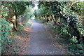
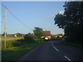
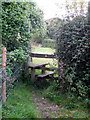
This page details the photographs taken nearby to Church Lane, MK16 8NZ by members of the Geograph project.
The Geograph project started in 2005 with the aim of publishing, organising and preserving representative images for every square kilometre of Great Britain, Ireland and the Isle of Man.

There are currently over 7.5m images from over14,400 individuals and you can help contribute to the project by visiting https://www.geograph.org.uk
Image Map
Images are licensed for reuse under creativecommons.org/licenses/by-sa/2.0
Notes
- Clicking on the map will re-center to the selected point.
- The higher the marker number, the further away the image location is from the centre of the postcode.
Image Listing (8 Images Found)
Images are licensed for reuse under creativecommons.org/licenses/by-sa/2.0
Image
Details
Distance
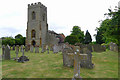
4
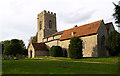
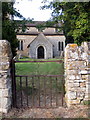
Parish Church of St Peter, Stoke Goldington
Image: © Chris Walpole
Taken: 27 Sep 2006
0.12 miles
5
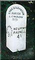
Old Milepost by the B526, High Street, Stoke Goldington
Bucks. pressing by the B526, in parish of Stoke Goldington (Milton Keynes District), High Street; 200m South of Church Lane junction, North West of Stoke Goldington Village, on wide well cut grass verge, under trees and bushes.
Lost since 2005.
Inscription reads:-
: NORTHAMPTON / 9¾ : : STOKE GOLDINGTON / PARISH / LONDON / 55 : : NEWPORT / PAGNELL / 4¾ :
Milestone Society National ID: BU_npnh05
Image: © Milestone Society
Taken: Unknown
0.14 miles