IMAGES TAKEN NEAR TO
Springbank Court, NEWPORT PAGNELL, MK16 8NA
Introduction
This page details the photographs taken nearby to Springbank Court, MK16 8NA by members of the Geograph project.
The Geograph project started in 2005 with the aim of publishing, organising and preserving representative images for every square kilometre of Great Britain, Ireland and the Isle of Man.

There are currently over 7.5m images from over14,400 individuals and you can help contribute to the project by visiting https://www.geograph.org.uk
Image Map
Images are licensed for reuse under creativecommons.org/licenses/by-sa/2.0
Notes
- Clicking on the map will re-center to the selected point.
- The higher the marker number, the further away the image location is from the centre of the postcode.
Image Listing (20 Images Found)
Images are licensed for reuse under creativecommons.org/licenses/by-sa/2.0
Image
Details
Distance
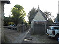
3
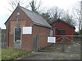
Telephone Exchange, Stoke Goldington
Situated in Mount Pleasant, this TE serves Stoke Goldington and Ravenstone nearby. The front building dates from the GPO era, but has been fitted more recently with ventilation louvres, presumably to keep it air-cooled. The brown wooden building behind it would have been added possibly during the 1970s to cope with an increase in telephone traffic. There is a BT warning notice on the metal gate. This TE has (01908) 551xxx numbers and its postcode is MK16 8LL.
Image: © David Hillas
Taken: 17 Mar 2012
0.12 miles
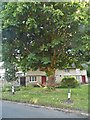
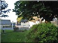
4
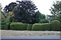
Topiary on High Street, Stoke Goldington
Image: © David Howard
Taken: 2 Aug 2022
0.13 miles
7
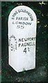
Old Milepost by the B526, High Street, Stoke Goldington
Bucks. pressing by the B526, in parish of Stoke Goldington (Milton Keynes District), High Street; 200m South of Church Lane junction, North West of Stoke Goldington Village, on wide well cut grass verge, under trees and bushes.
Lost since 2005.
Inscription reads:-
: NORTHAMPTON / 9¾ : : STOKE GOLDINGTON / PARISH / LONDON / 55 : : NEWPORT / PAGNELL / 4¾ :
Milestone Society National ID: BU_npnh05
Image: © Milestone Society
Taken: Unknown
0.14 miles
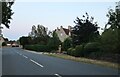
8
Green on High Street, Stoke Goldington
Image: © David Howard
Taken: 21 May 2017
0.18 miles
9
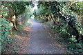
Dag Lane, Stoke Goldington
This is a bridleway with manure to prove it.
Image: © David Howard
Taken: 21 May 2017
0.19 miles
10
Green on High Street, Stoke Goldington
Image: © David Howard
Taken: 21 May 2017
0.20 miles