IMAGES TAKEN NEAR TO
Wolverton Road, NEWPORT PAGNELL, MK16 8JL
Introduction
This page details the photographs taken nearby to Wolverton Road, MK16 8JL by members of the Geograph project.
The Geograph project started in 2005 with the aim of publishing, organising and preserving representative images for every square kilometre of Great Britain, Ireland and the Isle of Man.

There are currently over 7.5m images from over14,400 individuals and you can help contribute to the project by visiting https://www.geograph.org.uk
Image Map
Images are licensed for reuse under creativecommons.org/licenses/by-sa/2.0
Notes
- Clicking on the map will re-center to the selected point.
- The higher the marker number, the further away the image location is from the centre of the postcode.
Image Listing (25 Images Found)
Images are licensed for reuse under creativecommons.org/licenses/by-sa/2.0
Image
Details
Distance
1
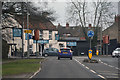
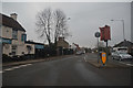
Newport Pagnell : Wolverton Road
Heading along Wolverton Road.
Image: © Lewis Clarke
Taken: 24 Mar 2018
0.05 miles
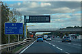
2
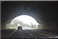
Newport Pagnell : Wolverton Road
Heading underneath the M1 Motorway.
Image: © Lewis Clarke
Taken: 24 Mar 2018
0.07 miles
3
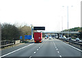
M1, Newport Pagnell
Heading south east towards London.
Image: © JThomas
Taken: 5 Mar 2012
0.09 miles
4
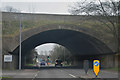
Milton Keynes : Wolverton Road
The road heads underneath the M1 Motorway and into Newport Pagnell.
Image: © Lewis Clarke
Taken: 24 Mar 2018
0.09 miles
5
Newport Pagnell : Wolverton Road
Looking along Wolverton Road in Newport Pagnell.
Image: © Lewis Clarke
Taken: 24 Mar 2018
0.09 miles
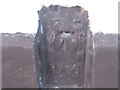
6
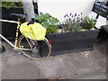
OS Flush Bracket Red House Pub
There is an OS Flush Bracket on this wall at the front of the Red House pub, albeit currently obscured by this planter.
Image: © Lord Richard Jewell
Taken: 24 Apr 2017
0.10 miles
7
Newport Pagnell : Wolverton Road
Looking along Wolverton Road beside The Red House.
Image: © Lewis Clarke
Taken: 5 Oct 2018
0.10 miles
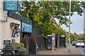
8
Newport Pagnell, near Red House
Looking west to the junctions of Wolverton Road and Little Linford Lane.
Image: © Peter Wood
Taken: 27 Nov 2012
0.10 miles
9
Ordnance Survey Flush Bracket 1785
This can be found on the wall of The Red House.
For more detail see : http://www.bench-marks.org.uk/bm706
Image: © Peter Wood
Taken: 27 Nov 2012
0.10 miles
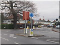
10
Borough of Milton Keynes : M1 Motorway
The M1 Motorway between Junction 15 (Collingtree) and Junction 14 (Broughton).
Image: © Lewis Clarke
Taken: 3 Oct 2018
0.10 miles