IMAGES TAKEN NEAR TO
Thorneycroft Lane, MILTON KEYNES, MK15 9BA
Introduction
This page details the photographs taken nearby to Thorneycroft Lane, MK15 9BA by members of the Geograph project.
The Geograph project started in 2005 with the aim of publishing, organising and preserving representative images for every square kilometre of Great Britain, Ireland and the Isle of Man.

There are currently over 7.5m images from over14,400 individuals and you can help contribute to the project by visiting https://www.geograph.org.uk
Image Map
Images are licensed for reuse under creativecommons.org/licenses/by-sa/2.0
Notes
- Clicking on the map will re-center to the selected point.
- The higher the marker number, the further away the image location is from the centre of the postcode.
Image Listing (24 Images Found)
Images are licensed for reuse under creativecommons.org/licenses/by-sa/2.0
Image
Details
Distance
1
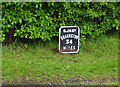
Milestone 34
Replica Grand Union milestone on towpath
Image: © Mike Todd
Taken: 18 May 2015
0.14 miles
2
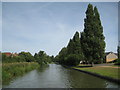
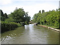
Grand Union Canal: Reach in Downhead Park
Poplar trees, like those on the right, line the canal for much of its reach through Milton Keynes.
Image: © Nigel Cox
Taken: 1 Sep 2013
0.15 miles
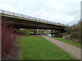
4
Portway Bridge No 81a
Carrying the A509 Portway across the Grand Union Canal in Milton Keynes.
Image: © Mat Fascione
Taken: 8 Aug 2015
0.19 miles
5
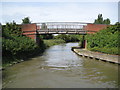
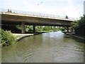
Grand Union Canal: Bridge Number 80A
Bridge Number 80A is a footbridge linking the Downhead Park and Willen Park areas of Milton Keynes.
Incidentally there is no Bridge Number 80 any more. This number was originally allocated to a long demolished (prior to Milton Keynes being built) swing bridge just to the north of where the entrance to the Pennyland Boat Basin is today. Curiously its location was between where Image and Image are today. If precedent elsewhere on the Grand Union Canal had been followed the latter should have been numbered Bridge Number 80.
Image: © Nigel Cox
Taken: 1 Sep 2013
0.19 miles
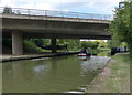
9
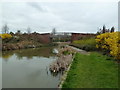
Grand Union Canal: Reach between Downhead Park and Willen Park
For the most part the canal is shielded from the houses in the new residential suburbs of Milton Keynes (and vice versa).
The old Victorian large scale map of this reach shows that there used to be a milestone on the towpath here, near to where the boat is moored, inscribed "To the Thames 60".
Image is visible in the distance.
Image: © Nigel Cox
Taken: 1 Sep 2013
0.20 miles
10
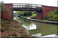
Grand Union Canal: Bridge Number 81A
Bridge Number 81A carries the A509 Portway over the canal. This is H5 in Milton Keynes' road grid system.
Image: © Nigel Cox
Taken: 1 Sep 2013
0.20 miles