IMAGES TAKEN NEAR TO
Selkirk Drive, MILTON KEYNES, MK14 6FH
Introduction
This page details the photographs taken nearby to Selkirk Drive, MK14 6FH by members of the Geograph project.
The Geograph project started in 2005 with the aim of publishing, organising and preserving representative images for every square kilometre of Great Britain, Ireland and the Isle of Man.

There are currently over 7.5m images from over14,400 individuals and you can help contribute to the project by visiting https://www.geograph.org.uk
Image Map
Images are licensed for reuse under creativecommons.org/licenses/by-sa/2.0
Notes
- Clicking on the map will re-center to the selected point.
- The higher the marker number, the further away the image location is from the centre of the postcode.
Image Listing (21 Images Found)
Images are licensed for reuse under creativecommons.org/licenses/by-sa/2.0
Image
Details
Distance
1
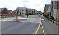
Selkirk Drive in Stantonbury Park
A new housing development on the northern edge of Milton Keynes.
Image: © Mat Fascione
Taken: 8 Aug 2015
0.06 miles
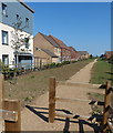
2

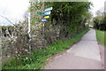
New footpath at Stantonbury Park
This path leads from Stantonbury Bridge No 75 on the Grand Union Canal, to the new housing development at Stantonbury Park, on the northern edge of Milton Keynes.
Image: © Mat Fascione
Taken: 8 Aug 2015
0.17 miles
4
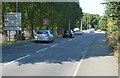
Wolverton Road at Stantonbury Park, Milton Keynes
Image: © Mat Fascione
Taken: 8 Aug 2015
0.19 miles
5
New path and houses at Stantonbury Park
A new housing development on the northern edge of Milton keynes.
Image: © Mat Fascione
Taken: 8 Aug 2015
0.19 miles
6
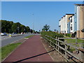
Wolverton Road at Stantonbury Park, Milton Keynes
Image: © Mat Fascione
Taken: 8 Aug 2015
0.21 miles
8
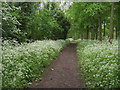
Swan's Way
Swan's Way heading to the Grand Union Canal
Image: © Shaun Ferguson
Taken: 16 May 2014
0.22 miles
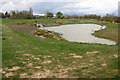
9
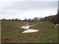
Stonepit Field Lakes
These new lakes were developed during 2008 by the Milton Keynes Parks Trust to help control floodwater from a nearby new housing development and to provide wetland habitat. In spring 2009 they are only slowly filling up with rainwater. The building on the horizon is the Black Horse pub on the north bank of the Grand Union Canal. You can see the notice about the development athttp://www.geograph.org.uk/photo/1201517
Image: © Wendy Carey
Taken: 13 Mar 2009
0.23 miles
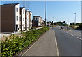
10
Wolverton Road in Milton Keynes
This is the northern edge of the town.
Image: © Mat Fascione
Taken: 8 Aug 2015
0.23 miles