IMAGES TAKEN NEAR TO
Temple, MILTON KEYNES, MK14 6AW
Introduction
This page details the photographs taken nearby to Temple, MK14 6AW by members of the Geograph project.
The Geograph project started in 2005 with the aim of publishing, organising and preserving representative images for every square kilometre of Great Britain, Ireland and the Isle of Man.

There are currently over 7.5m images from over14,400 individuals and you can help contribute to the project by visiting https://www.geograph.org.uk
Image Map
Images are licensed for reuse under creativecommons.org/licenses/by-sa/2.0
Notes
- Clicking on the map will re-center to the selected point.
- The higher the marker number, the further away the image location is from the centre of the postcode.
Image Listing (10 Images Found)
Images are licensed for reuse under creativecommons.org/licenses/by-sa/2.0
Image
Details
Distance
1
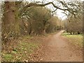
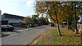
Path, Stantonbury
You're never all that far from somewhere vaguely semi-rural in Milton Keynes, and these trees have been here far longer than the estates that surround them. The path is heading towards Wood End School.
Image: © Derek Harper
Taken: 4 Feb 2011
0.11 miles
2

Shopping area, Stantonbury
A colourful cycle-oriented mural decorates the end wall of a parade of shops, including the advertised fish bar, which I patronised.
Image: © Derek Harper
Taken: 4 Feb 2011
0.15 miles
7
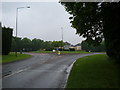
Marlborough Roundabout
The view from SP8441 of the Marlborough Roundabout, which falls on the line between this square and SP8341.
Image: © Mr Biz
Taken: 28 May 2008
0.21 miles
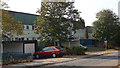
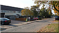
8

Stantonbury Campus
Saxon Hall at Stantonbury Campus. Stantonbury is probably the largest secondary school in Europe.
Image: © Richard Schmidt
Taken: 3 Sep 2006
0.21 miles
9
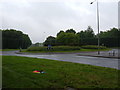
Marlborough Roundabout
This roundabout is unique to Milton Keynes as it is the only one on the grid system to adjoin two "V" (vertical) roads and no "H" (horizontal), connecting the top of V8 Marlborough Street to V7 Saxon Street. The roundabout also falls over two different grid squares, with this the view eastwards.
Image: © Mr Biz
Taken: 28 May 2008
0.22 miles
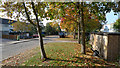
10
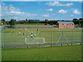
Stantonbury Sports
Stantonbury has fantastic sports facilities, as can be seen from the astroturf pitches in the foreground and the athletics track in the midground. On the right is the recently built pavilion for the athletics track, which is home to Milton Keynes Athletics Club.
Image: © Richard Schmidt
Taken: 3 Sep 2006
0.24 miles