IMAGES TAKEN NEAR TO
Butlers Grove, MILTON KEYNES, MK14 5DT
Introduction
This page details the photographs taken nearby to Butlers Grove, MK14 5DT by members of the Geograph project.
The Geograph project started in 2005 with the aim of publishing, organising and preserving representative images for every square kilometre of Great Britain, Ireland and the Isle of Man.

There are currently over 7.5m images from over14,400 individuals and you can help contribute to the project by visiting https://www.geograph.org.uk
Image Map
Images are licensed for reuse under creativecommons.org/licenses/by-sa/2.0
Notes
- Clicking on the map will re-center to the selected point.
- The higher the marker number, the further away the image location is from the centre of the postcode.
Image Listing (18 Images Found)
Images are licensed for reuse under creativecommons.org/licenses/by-sa/2.0
Image
Details
Distance
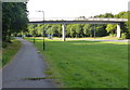
2
Looking down Parklands towards the church
St Andrews Church (12th century) appears between Parklands houses built in the 1970's for the new city of Milton Keynes
Image: © Wendy Carey
Taken: 17 Mar 2009
0.20 miles
3
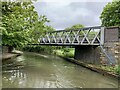
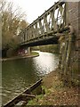
Great Linford Railway Bridge No 76A
This former railway bridge built in 1867, now carries the Midshires Way footpath across the Grand Union Canal.
Image: © Mat Fascione
Taken: 8 Aug 2015
0.21 miles
4
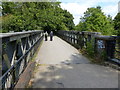
Path across the Great Linford Railway Bridge No 76A
This former railway bridge built in 1867, now carries the Midshires Way footpath across the Grand Union Canal.
Image: © Mat Fascione
Taken: 8 Aug 2015
0.21 miles
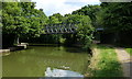
5
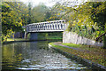
Bridge 76A, Grand Union Canal
This substantial bridge once carried the Wolverton - Newport Pagnell railway branch but has now been demoted to the status of a footbridge. The last train ran in 1967.
Image: © Stephen McKay
Taken: 11 Nov 2019
0.21 miles
6
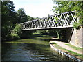
Grand Union Canal: Bridge Number 76A
Bridge Number 76A was built by the London & North Western Railway in 1867 on the route of their branch line from Wolverton to Newport Pagnell. The railway was a victim of Dr Beeching and closed to passenger traffic in 1964 and to goods trains in 1967 after 100 years of service. Old Ordnance Survey maps show that there was a railway milepost at the right end of the bridge here inscribed Newport Pagnell 2.
The bridge has been retained to carry a footpath over the canal, and this now forms a section of the long distance Midshires Way.
Image: © Nigel Cox
Taken: 1 Sep 2013
0.21 miles
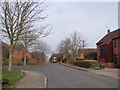
7
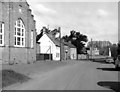
High Street, Great Linford, Buckinghamshire
Image: © Dr Neil Clifton
Taken: 14 Apr 1974
0.21 miles
8
Newport Pagnell branch line bridge
Over the Grand Union Canal.
Image: © Andrew Abbott
Taken: 15 May 2021
0.21 miles
9
Bridge across Grand Union Canal
A summer view of the former railway bridge is shown in Image
Image: © Derek Harper
Taken: 4 Feb 2011
0.21 miles
10
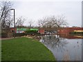
Peartree Pond at Great Linford shops
One of the original village ponds has been engineered to enhance the small shopping centre built in the 1970's
Image: © Wendy Carey
Taken: 17 Mar 2009
0.21 miles