IMAGES TAKEN NEAR TO
Nightingale Crescent, MILTON KEYNES, MK13 7UE
Introduction
This page details the photographs taken nearby to Nightingale Crescent, MK13 7UE by members of the Geograph project.
The Geograph project started in 2005 with the aim of publishing, organising and preserving representative images for every square kilometre of Great Britain, Ireland and the Isle of Man.

There are currently over 7.5m images from over14,400 individuals and you can help contribute to the project by visiting https://www.geograph.org.uk
Image Map
Images are licensed for reuse under creativecommons.org/licenses/by-sa/2.0
Notes
- Clicking on the map will re-center to the selected point.
- The higher the marker number, the further away the image location is from the centre of the postcode.
Image Listing (88 Images Found)
Images are licensed for reuse under creativecommons.org/licenses/by-sa/2.0
Image
Details
Distance
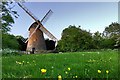
1
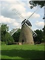
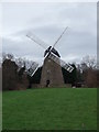
Bradwell Windmill
The New Bradwell Windmill was originally built on an acre of land purchased by Samuel Holman in 1803. Valuations of the time indicate that it cost in the region of £500 to build.
By 1876 the mill was no longer in operation. The mill was bought by the Development Corporation in 1969 and underwent restoration work.
Image: © Cameraman
Taken: 16 Sep 2007
0.01 miles
2
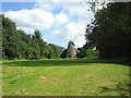
Bradwell Windmill
A group of local people have formed "The Friends of Bradwell Mill", aiming to improve, maintain and promote the Mill as a valuable example of local history. They organise open days and events so that people can become involved and be able to see the windmill inside. There is a mayday event which includes local people and organisations running stalls and maypole dancing amongst other entertainments on the Green in front of the windmill.
See Image for details.
Image: © Cameraman
Taken: 16 Sep 2007
0.02 miles
3
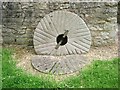
Old Millstones
Placed in front of the windmill.
See Image for details.
Image: © Cameraman
Taken: 16 Sep 2007
0.02 miles
4
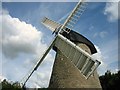
Bradwell Windmill
The windmill sails.
See Image for details.
Image: © Cameraman
Taken: 16 Sep 2007
0.02 miles
5
Bradwell Windmill
This easily recognisable landmark proves that Milton Keynes has a long and varied history even if it is best known for its modern development.
Image: © Richard Schmidt
Taken: 24 Feb 2007
0.03 miles
6
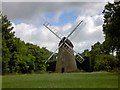
Milton Keynes windmill
From Nightingale Crescent.
http://www.windmillworld.com/millid/1696.htm
Image: © Steve Fareham
Taken: 10 Jul 2008
0.03 miles
7
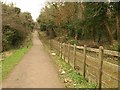
Path, Bradville
The straight path, leading ENE from the right-hand bridge shown in Image, runs close to Bradwell Windmill (see http://www.geograph.org.uk/search.php?i=20013616 ) above to the right, but a clear view of the windmill is not possible.
Image: © Derek Harper
Taken: 4 Feb 2011
0.04 miles
8
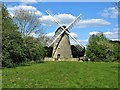
Bradwell Windmill, Milton Keynes
Built in the early 1800s next to the Grand Union Canal, the limestone Bradwell Windmill worked to about 1876. It has recently been restored to full working order and is a Grade II listed building. Some of the information in the listing page appears to be incorrect, so I have not included a link to the Grade II listing.
Image: © G Laird
Taken: 16 May 2019
0.04 miles
10
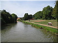
Grand Union Canal: Reach in New Bradwell
The old village of New Bradwell is behind the trees and was developed primarily for employees of the nearby Wolverton Carriage Works and their families. Today the urban sprawl of Milton Keynes has butted up to the old village and encompassed it.
Image: © Nigel Cox
Taken: 1 Sep 2013
0.06 miles