IMAGES TAKEN NEAR TO
Wylie End, MILTON KEYNES, MK13 7FA
Introduction
This page details the photographs taken nearby to Wylie End, MK13 7FA by members of the Geograph project.
The Geograph project started in 2005 with the aim of publishing, organising and preserving representative images for every square kilometre of Great Britain, Ireland and the Isle of Man.

There are currently over 7.5m images from over14,400 individuals and you can help contribute to the project by visiting https://www.geograph.org.uk
Image Map
Images are licensed for reuse under creativecommons.org/licenses/by-sa/2.0
Notes
- Clicking on the map will re-center to the selected point.
- The higher the marker number, the further away the image location is from the centre of the postcode.
Image Listing (45 Images Found)
Images are licensed for reuse under creativecommons.org/licenses/by-sa/2.0
Image
Details
Distance
1
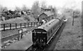
Bradwell Station, with train
View NE, towards Newport Pagnell; ex-LNW Wolverton - Newport Pagnell branch. Station and branch closed to passengers 7/9/64, for goods 22/5/67. An auto-train is working the branch, powered by an Ivatt Class 3MT 2-6-2T. (The site is of course now enveloped in the New Town of Milton Keynes).
Image: © Ben Brooksbank
Taken: 12 May 1962
0.01 miles
2
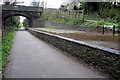
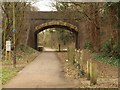
Disused station and bridge over the Railway Walk
Image: © Philip Jeffrey
Taken: 14 Apr 2012
0.06 miles
3
Swan's Way
Swan's Way heading under the Bradwell Road bridge along the old railway line
Image: © Shaun Ferguson
Taken: 16 May 2014
0.06 miles
4
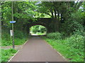
Bridge over cyclepath, Milton Keynes
Bradwell Road crosses the path shown in Image, using an old railway bridge.
Image: © Derek Harper
Taken: 4 Feb 2011
0.06 miles
5
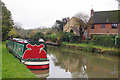
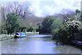
Grand Union Canal, New Bradwell
A narrowboat is moored just east of bridge 72. The houses backing on to the canal are on Chipperfield Close.
Image: © Stephen McKay
Taken: 14 Nov 2019
0.08 miles
6
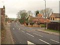
Bradwell Road
On the left can be seen the inn sign for The New Inn http://www.britishlistedbuildings.co.uk/en-45482-the-new-inn-new-bradwell . On the other side of the road is Chipperfield Close. Just after these the road crosses the disused railway shown in Image
Image: © Derek Harper
Taken: 4 Feb 2011
0.08 miles
7
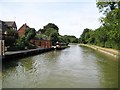
Grand Union Canal: Reach in Bradville
The residents of Chipperfield Close on the left have moorings at the bottoms of their gardens.
Image: © Nigel Cox
Taken: 1 Sep 2013
0.09 miles
8
Grand Union Canal
In Bradville, Milton Keynes
Image: © Andrew Abbott
Taken: 19 May 2021
0.09 miles
9
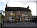
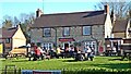
The New Inn Pub, New Bradwell
Bradwell Road, New Bradwell, Milton Keynes, MK13 0EN on the Grand Union Canal
Image: © canalandriversidepubs co uk
Taken: Unknown
0.09 miles