IMAGES TAKEN NEAR TO
Stantonbury Close, MILTON KEYNES, MK13 0EY
Introduction
This page details the photographs taken nearby to Stantonbury Close, MK13 0EY by members of the Geograph project.
The Geograph project started in 2005 with the aim of publishing, organising and preserving representative images for every square kilometre of Great Britain, Ireland and the Isle of Man.

There are currently over 7.5m images from over14,400 individuals and you can help contribute to the project by visiting https://www.geograph.org.uk
Image Map
Images are licensed for reuse under creativecommons.org/licenses/by-sa/2.0
Notes
- Clicking on the map will re-center to the selected point.
- The higher the marker number, the further away the image location is from the centre of the postcode.
Image Listing (47 Images Found)
Images are licensed for reuse under creativecommons.org/licenses/by-sa/2.0
Image
Details
Distance
1
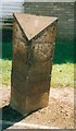
Old Milepost by Newport Road, New Bradwell
Cast iron post by the UC road, in parish of Stantonbury (Milton Keynes District), Newport Road; opposite abandoned filling station at New Bradwell, just West of St Peter's way, on cut grass between path and end of house wall, on South side of road. Newport twin plaque, erected by the Buckingham & Newport Pagnell turnpike trust in the 19th century.
Inscription reads:-
: BUCKINGHAM / 11 / STRATFORD / 3 : : NEWPORT / 3 / STRATFORD / 3 :
Milestone Society National ID: BU_BUNP11
Image: © A Rosevear & J Higgins
Taken: 2 Aug 2003
0.03 miles
2
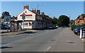
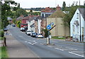
The Foresters Arms on Newport Road
In New Bradwell on the northern edge of Milton Keynes.
Image: © Mat Fascione
Taken: 8 Aug 2015
0.08 miles
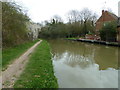
5
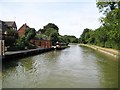
Grand Union Canal: Reach in Bradville
The residents of Chipperfield Close on the left have moorings at the bottoms of their gardens.
Image: © Nigel Cox
Taken: 1 Sep 2013
0.13 miles
6
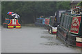
Grand Union Canal, New Bradwell
Taken in torrential rain. Boaters keep going in all weathers; the boat ahead has found one way of keeping dry.
Image: © Stephen McKay
Taken: 18 Aug 2007
0.13 miles
7
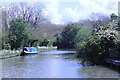
Grand Union Canal
In Bradville, Milton Keynes
Image: © Andrew Abbott
Taken: 19 May 2021
0.13 miles
8
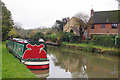
Grand Union Canal, New Bradwell
A narrowboat is moored just east of bridge 72. The houses backing on to the canal are on Chipperfield Close.
Image: © Stephen McKay
Taken: 14 Nov 2019
0.13 miles
9
Bridge 73, Grand Junction Canal
According to an 1881 edition of the O/S map, a swing bridge was located in this position. Signs of the smoothed out embankment can still be seen on the north side of the canal in the back garden of a small block of flats in New Bradwell. Contour lines on current day O/S maps also indicate this with a sharp kink to the north in the natural line.
Image: © Mr Biz
Taken: 31 Mar 2012
0.15 miles
10
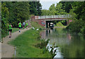
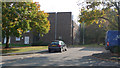
Bradwell Bridge No 72
Carrying Bradwell Road across the Grand Union Canal, in the New Bradwell area of Milton Keynes.
Image: © Mat Fascione
Taken: 8 Aug 2015
0.15 miles