IMAGES TAKEN NEAR TO
White Alder, MILTON KEYNES, MK12 6HF
Introduction
This page details the photographs taken nearby to White Alder, MK12 6HF by members of the Geograph project.
The Geograph project started in 2005 with the aim of publishing, organising and preserving representative images for every square kilometre of Great Britain, Ireland and the Isle of Man.

There are currently over 7.5m images from over14,400 individuals and you can help contribute to the project by visiting https://www.geograph.org.uk
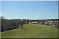
Image Map
Images are licensed for reuse under creativecommons.org/licenses/by-sa/2.0
Notes
- Clicking on the map will re-center to the selected point.
- The higher the marker number, the further away the image location is from the centre of the postcode.
Image Listing (11 Images Found)
Images are licensed for reuse under creativecommons.org/licenses/by-sa/2.0
Image
Details
Distance
3
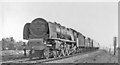
Stanier 'Princess Coronation' 8P approaching Wolverton, WCML 1957
As I neared the end of my track-side walk from Bletchley on Cup Final Day 1957, No. 46237 'City of Bristol' rushed past me on the 14.30 Euston to Liverpool - seeming to lack a chimney, which was wreathed in smoke - but the smoke-deflectors were doing their job. (No. 46237, never streamlined, was built 8/39 and lasted until 9/64).
Image: © Ben Brooksbank
Taken: 4 May 1957
0.14 miles
5
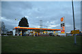
Milton Keynes : Shell Petrol Station
Looking towards a Shell garage from H3 Monks Way.
Image: © Lewis Clarke
Taken: 18 Mar 2019
0.21 miles
6
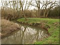
Loughton Brook
A double meander on the stream as it flows (to the right) through North Loughton Valley Park.
Image: © Derek Harper
Taken: 4 Feb 2011
0.21 miles
7
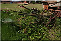
Milton Keynes Museum's graveyard
In every other respect a fabulous place, cannot recommend it enough, but certain items seem to have been abandoned to their fate. Pity they were moved from their former position on the hard-standing.
Image: © Chris
Taken: 28 May 2015
0.22 miles
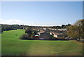
8
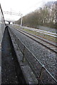
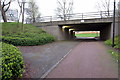
Charter train on the incline siding
The incline siding gives access to Wolverton railway works going under the down slow, up fast and down fast lines south of Wolverton station. The line on the right is the up slow.
Image: © Roger Templeman
Taken: 28 Jan 2012
0.23 miles
10
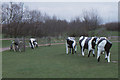
Milton Keynes: the famous concrete cows
In the 1970s and 1980s, these were the most famous thing about Milton Keynes to outsiders, and I would look out for them every time I was on a train along the West Coast Main Line. Nowadays the trees have grown up and although the cows are right next to the line they are hard to see; I don't hear them mentioned as often, either, so it may be that Milton Keynes' image is changing a little.
Image: © Christopher Hilton
Taken: 19 Mar 1989
0.24 miles