IMAGES TAKEN NEAR TO
Sinclair Court, MILTON KEYNES, MK1 1RB
Introduction
This page details the photographs taken nearby to Sinclair Court, MK1 1RB by members of the Geograph project.
The Geograph project started in 2005 with the aim of publishing, organising and preserving representative images for every square kilometre of Great Britain, Ireland and the Isle of Man.

There are currently over 7.5m images from over14,400 individuals and you can help contribute to the project by visiting https://www.geograph.org.uk
Image Map
Images are licensed for reuse under creativecommons.org/licenses/by-sa/2.0
Notes
- Clicking on the map will re-center to the selected point.
- The higher the marker number, the further away the image location is from the centre of the postcode.
Image Listing (22 Images Found)
Images are licensed for reuse under creativecommons.org/licenses/by-sa/2.0
Image
Details
Distance

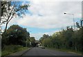
2
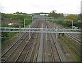
Milton Keynes: West Coast Main Line
Massed ranks of gantries supporting the overhead power lines dominate the scene, viewed from the Spenlows Road footbridge. The tracks diverging to the right from the junction with the main line eventually lead, bypassing Bletchley station, to the now-disused line to Bicester and Oxford, which is only currently in use as far as the Newton Longville landfill site. For a view in the opposite direction please see Image
Image: © Nigel Cox
Taken: 1 May 2010
0.03 miles
3
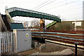
Footbridge over the west coast mainline
Image: © Philip Jeffrey
Taken: 23 Mar 2012
0.04 miles
4
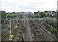
Milton Keynes: West Coast Main Line
Massed ranks of gantries supporting the overhead power lines dominate the scene, viewed from the Spenlows Road footbridge. The tracks on the left, beyond the weedy siding, head towards the now-disused line to Bicester and Oxford, which is only currently in use as far as the Newton Longville landfill site. This track bypasses Bletchley station. For a view in the opposite direction please see Image
Image: © Nigel Cox
Taken: 1 May 2010
0.09 miles
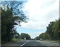
5
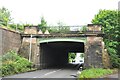
Denbigh Hall railway bridge over Watling Street
This bridge takes the West Coast Main Line over Watling Street (once the A5). The railway tracks skew sharply over the road, hence the length of the tunnel like structure. This point was where prior to September 1838, passengers had to change to a road coach and travel to Rugby to regain the railway. This was due to the late completion of Kilsby Tunnel, south of Rugby, which had many problems with its construction.
Image: © Bob Walters
Taken: 23 Jun 2022
0.11 miles
6
Railway bridge over Watling Street
Near Granby. This is the West Coast Main Line
Image: © John Firth
Taken: 22 Sep 2013
0.11 miles
7
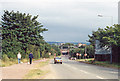
SE on A5 Watling Street, approaching Denbigh Hall Bridge
View SE, towards London. The bridge carries the ex-LNWR West Coast Main Line over the A5, where from 9/4 - 17/9/1838 the pioneering London & Birmingham Railway had to establish a temporary Station to allow passengers to transfer to stage-coaches to take them on to Rugby, while the Kilsby Tunnel was completed.
Image: © Ben Brooksbank
Taken: 18 Aug 1991
0.13 miles
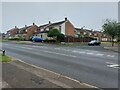
8
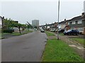
Melrose Avenue, Bletchley, Milton Keynes
A wide residential street in the Bletchley area of Milton Keynes.
Image: © Graham Robson
Taken: 28 Jun 2021
0.14 miles
9
Denbigh West industry turn off from Watling Street
Image: © John Firth
Taken: 22 Sep 2013
0.16 miles
10
Whalley Drive, Bletchley, Milton Keynes
The junction of a Banburies Close, a residential cul-de-sac, with Whalley Drive in Bletchley.
Image: © Graham Robson
Taken: 28 Jun 2021
0.17 miles